 Filter: Categories of Wisconsin Historical Images
Filter: Subject of Engraving
Filter: Subject of trees
Filter: Categories of Wisconsin Historical Images
Filter: Subject of Engraving
Filter: Subject of trees

| Date: | 1755 |
|---|---|
| Description: | Map of New England, with three inset maps of Fort Oswego, Fort du Quesne, and Fort Frederick. It shows colonies, a few cities, forts (marked as French or E... |

| Date: | 1795 |
|---|---|
| Description: | Map of Vermont showing counties, townships, cities, roads, mountains, lakes, and rivers. A forest and waterfall scene decorates the title cartouche in the ... |

| Date: | 1795 |
|---|---|
| Description: | Map of Massachusetts showing counties, cities, roads, islands (including Nantucket and Martha's Vineyard), mountains, hills, lakes, and rivers. Two small e... |

| Date: | 1758 |
|---|---|
| Description: | Map of Rhode Island and Connecticut, showing counties, townships, cities, roads, islands, mountains, lakes and rivers. Trees and a frame decorates the titl... |

| Date: | 1795 |
|---|---|
| Description: | Map of Connecticut showing counties, townships, cities, roads, islands, swamps, hills, mountains, lakes, rivers, reefs, and numerous other geographical and... |

| Date: | 03 1777 |
|---|---|
| Description: | Map showing the British and Hessian attack on Fort Washington in November of 1776. The movements and fortifications of the British and Hessian troops appea... |

| Date: | 1756 |
|---|---|
| Description: | Map of Pennsylvania, showing cities, towns, roads, trading paths, portages, forts, mountains, swamps, waterfalls, lakes, and rivers. The map further includ... |

| Date: | 1776 |
|---|---|
| Description: | Map of the Delaware Bay, River, their shoreline, made to aid ships in navigating to Philadelphia. It is oriented with north to the right and shows inlets, ... |

| Date: | 1780 |
|---|---|
| Description: | Map of Maryland and a portion of the surrounding provinces. It shows the boundary lines and borders, counties, cities, towns, roads, mountains, bays, and r... |

| Date: | 1673 |
|---|---|
| Description: | Decorative map of the southeastern region of North America, from the York River in Virginia to northern Florida. The coat of arms of France and England mar... |

| Date: | 1667 |
|---|---|
| Description: | Map of Virginia depicting the discoveries detailed by John Smith in his exploration of the region. It shows Jamestown, Native American tribes and villages,... |

| Date: | 1671 |
|---|---|
| Description: | Map of Virginia depicting the discoveries detailed by John Smith in his exploration of the region. It shows Jamestown, Native American tribes and villages,... |

| Date: | 1676 |
|---|---|
| Description: | Map of Virginia and Maryland, based on John Smith's 1612 map and Augustine Herman's 1673 seminal map. It shows borders, counties, Native American land, tri... |

| Date: | 1760 |
|---|---|
| Description: | Map showing the towns, mountains, valleys, corn fields, and rivers of a portion of the Cherokee Nation. A few annotations on the map explain the land and r... |

| Date: | 1779 |
|---|---|
| Description: | Map of colonial Georgia showing cities, towns, Native American land and towns, forts, roads, trading paths, islands, mountains, swamps, and rivers. Annotat... |

| Date: | 1766 |
|---|---|
| Description: | Map of the region south of Lake Erie to the Ohio River. It shows forts, towns, Native American towns, mines, roads, mountains, swamps, lakes, and rivers. T... |
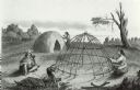
| Date: | 1884 |
|---|---|
| Description: | A completed Chippewa (Ojibwa) lodge and a lodge under construction. A Native American woman is stitching something on the completed lodge. Another Native A... |
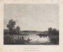
| Date: | 1858 |
|---|---|
| Description: | Engraved print of four men and a dog in a boat on Lake Winnebago. Two of the men are in the center of the boat holding hunting rifles, while one man is sta... |
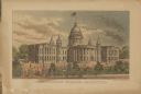
| Date: | |
|---|---|
| Description: | Elevated view of the Wisconsin State Capitol. Pedestrians are strolling along the grounds near a fountain. |
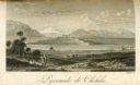
| Date: | 1816 |
|---|---|
| Description: | The four-stepped, low-rising Pyramid of Cholula, covered in sparse vegetation, stands in a flat valley, surrounded by distant mountains. A stairway leads u... |
If you didn't find the material you searched for, our Library Reference Staff can help.
Call our reference desk at 608-264-6535 or email us at: