 Filter: Categories of Wisconsin Historical Images
Filter: Subject of Engraving
Filter: Subject of mountains
Filter: Subject of industries
Filter: Categories of Wisconsin Historical Images
Filter: Subject of Engraving
Filter: Subject of mountains
Filter: Subject of industries

| Date: | 1782 |
|---|---|
| Description: | Map of the West Indies and south eastern North America, remarkably detailed, showing cities, mountains, rivers, lakes, mines, plantations, forts, banks, an... |

| Date: | 1783 |
|---|---|
| Description: | This map is hand-colored and shows the boundaries of British, Spanish, and the newly recognized American claims, as well as the fishing rights granted to F... |

| Date: | 1719 |
|---|---|
| Description: | Map of North America showing political boundaries, areas of Indian habitation, cities, towns, ports, rivers, mines, and other notable for North America fro... |

| Date: | 1745 |
|---|---|
| Description: | Landmark map of the Great Lakes region and one of the most advanced depictions of the lakes and surrounding areas for its time. It is the first map to intr... |

| Date: | 1720 |
|---|---|
| Description: | Map of North America from from the Rio Grande to the Atlantic Ocean, showing boundaries, the colonies, cities, settlements, mines, forts, Native American l... |

| Date: | 1765 |
|---|---|
| Description: | Detailed map composed for the London Magazine of the Mississippi River Valley at the conclusion of the French and Indian War. The British colonies themselv... |

| Date: | 1720 |
|---|---|
| Description: | Detailed, ornate, and comprehensive map of America from the east coast to present day Texas. Numerous features appear throughout the map, including Native ... |

| Date: | 1782 |
|---|---|
| Description: | Map of America covering the Rio Grande to the Atlantic Ocean, showing boundaries, the colonies, cities, settlements, Native American lands and villages, m... |

| Date: | 1792 |
|---|---|
| Description: | Map of the United States east of the Mississippi River and north of the Ohio River. It shows the borders between the north eastern states, Canada and the U... |

| Date: | 1794 |
|---|---|
| Description: | Extremely detailed map of the south-eastern states, south from Virginia and east of the Mississippi River. It shows roads and paths, cities, towns, forts, ... |

| Date: | 1795 |
|---|---|
| Description: | Heavily detailed and rare map of the United States. The map features the states, territories, cities, towns, forts, mines, mountains, swamps, lakes, and ri... |

| Date: | 1805 |
|---|---|
| Description: | Map of the United States. It shows the states, cities, towns, Native American land, mountains, lakes, and rivers. Tennessee, Kentucky, and Ohio are labeled... |

| Date: | 1800 |
|---|---|
| Description: | Map of the United States. It shows the states, including Tennessee, cities, towns, Native American land, mountains, lakes, and rivers. Lead mines appear ju... |
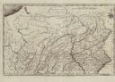
| Date: | 1795 |
|---|---|
| Description: | Map of Pennsylvania showing counties, cities, roads, quarries, roads, mountains, lakes and rivers. |

| Date: | 1755 |
|---|---|
| Description: | Map of Virginia and parts of Maryland, North Carolina, and New Jersey. It shows borders, boundary lines, some Native American land, counties, cities, towns... |

| Date: | 1781 |
|---|---|
| Description: | Map of the Southeastern part of the British Colonies in North America, Gulf Coast and Caribbean. It illustrates the of the Spanish and English fleets, part... |

| Date: | 1720 |
|---|---|
| Description: | Map showing the course of the Mississippi River from the Gulf of Mexico up past Lake Superior into Canada. It shows the towns, Native American tribes and l... |

| Date: | 1766 |
|---|---|
| Description: | Map of the region south of Lake Erie to the Ohio River. It shows forts, towns, Native American towns, mines, roads, mountains, swamps, lakes, and rivers. T... |
If you didn't find the material you searched for, our Library Reference Staff can help.
Call our reference desk at 608-264-6535 or email us at: