 Filter: Categories of Wisconsin Historical Images
Filter: Subject of Engraving
Filter: Subject of human settlements
Filter: Subject of flowers
Filter: Categories of Wisconsin Historical Images
Filter: Subject of Engraving
Filter: Subject of human settlements
Filter: Subject of flowers
| Date: | |
|---|---|
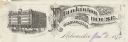
| Description: | Letterhead of Plankinton House in Milwaukee, Wisconsin, with a three-quarter view of the hotel and traffic in the street, including people on foot, on hors... |

| Date: | 01 1869 |
|---|---|
| Description: | Engraving after a drawing by Winslow Homer showing a crowned Baby New Year riding a velocipede through a hoop held by a woman, as the Grim Reaper, on the r... |

| Date: | 1780 |
|---|---|
| Description: | This map portrays North and South America at a very unusual angle, with north oriented towards the upper right corner. Colonies, Native American land, a fe... |

| Date: | 1759 |
|---|---|
| Description: | Map of North and South America showing regions, colonies, cities and settlements, rivers, lakes, and Native American land. Near the bottom left an inset ma... |

| Date: | 1763 |
|---|---|
| Description: | Map of America and part of Canada including the borders of European claims after the French and Indian War. Cities, forts, Native American lands, rivers, l... |

| Date: | 1755 |
|---|---|
| Description: | Map of colonial America, showing the lands north of South Carolina and west of the Mississippi River. An inset map of the Carolinas and Georgia sits in the... |

| Date: | 1780 |
|---|---|
| Description: | Detailed map of America east of the Louisiana region. It shows forts, cities, borders and boundary lines, Native American land, the post road, mountains, w... |

| Date: | 1795 |
|---|---|
| Description: | Map of Connecticut showing counties, townships, cities, roads, islands, swamps, hills, mountains, lakes, rivers, reefs, and numerous other geographical and... |

| Date: | 1784 |
|---|---|
| Description: | Map of the southeastern region of America to just west of the Mississippi River. It shows borders, cities, towns, forts, Native American land, portages, mo... |

| Date: | 1776 |
|---|---|
| Description: | Map of Virginia and parts of Maryland and Delaware (written "De La War"). It shows borders, counties, cities, towns, plantations (marked by landowners name... |

| Date: | 1761 |
|---|---|
| Description: | Map covering southern Louisiana from Lake Ponchetrain to the Golf of Mexico and from Woods Bay in the west to the islands just east of Bay St. Louis. It sh... |
If you didn't find the material you searched for, our Library Reference Staff can help.
Call our reference desk at 608-264-6535 or email us at: