Map or Atlas
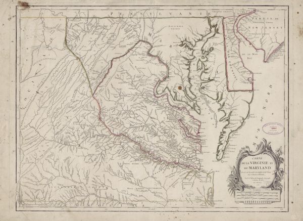
Carte de la Virginie et du Maryland

| Map of Virginia and parts of Maryland and Delaware (written "De La War"). It shows borders, counties, cities, towns, plantations (marked by landowners name), roads, swamps, mountains, islands, bays, lakes, and rivers. While the title is in French, most of the place names and annotations appear in English, with the occasional French translation in brackets. The title cartouche sits in the lower right corner framed by flowers, corn, tobacco, and waves. |
| Image ID: | 124713 |
|---|---|
| Creation Date: | circa 1776 |
| Creator Name: | Vaugondy, Robert de |
| City: | |
| County: | |
| State: | |
| Collection Name: | Map Collection |
| Genre: | Map or Atlas |
| Original Format Type: | prints, fine-art |
| Original Format Number: | H GX863 1755 F |
| Original Dimensions: | 49 x 64 cm, on sheet 53 x 72 cm |
| French edition of the Fry-Jefferson map A Map of the Most Inhabited Part of Virginia. This copy is the third of five known states of this French edition. For the original English map see image ID: 124712 |
| Rivers |
| Flowers |
| Plants |
| Cities and towns |
| Islands |
| Marshes |
| Mountains |
| Engraving |
| Plantations |
| Croplands |
| Roads |
| Bays |
| Lakes |
| This image is issued by the Wisconsin Historical Society. Use of the image requires written permission from the staff of the Collections Division. It may not be sold or redistributed, copied or distributed as a photograph, electronic file, or any other media. The image should not be significantly altered through conventional or electronic means. Images altered beyond standard cropping and resizing require further negotiation with a staff member. The user is responsible for all issues of copyright. Please Credit: Wisconsin Historical Society. |
| Location: | Wisconsin Historical Society Archives, 4th Floor, Madison, Wisconsin |
|---|
