 Filter: Categories of Wisconsin Historical Images
Filter: Subject of Engraving
Filter: Subject of cities and towns
Filter: Subject of agriculture
Filter: Categories of Wisconsin Historical Images
Filter: Subject of Engraving
Filter: Subject of cities and towns
Filter: Subject of agriculture
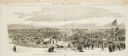
| Date: | 10 24 1863 |
|---|---|
| Description: | Panoramic wood-engraving of a cattle fair in New Haven, after a sketch by H.C. Curtis. Caption reads: "Cattle Show and Agricultural Faib [sic] at Ha... |

| Date: | 1835 |
|---|---|
| Description: | Two-story home with sloping roof. One man is whipping a team of eight cattle while another man drives the plow behind them. To the left stands a man near a... |
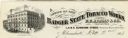
| Date: | |
|---|---|
| Description: | Letterhead of the Badger State Tobacco Works of Milwaukee, Wisconsin, with a three-quarter view of the building, men working on boats moored near the water... |
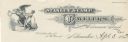
| Date: | |
|---|---|
| Description: | Letterhead of Stanley & Camp, Jewelers, of Milwaukee, Wisconsin. Features a winged Father Time holding a large pocket watch in an extended hand, while a yo... |

| Date: | |
|---|---|
| Description: | Letterhead of the William Rahr Sons' Company of Manitowoc, Wisconsin, "Maltsters and Roasters," with an elevated view of the company building on one side o... |
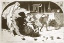
| Date: | 01 1869 |
|---|---|
| Description: | Engraving after a drawing by Winslow Homer showing a crowned Baby New Year riding a velocipede through a hoop held by a woman, as the Grim Reaper, on the r... |

| Date: | 1770 |
|---|---|
| Description: | The south west sheet of a four sheet map of Virginia, showing the counties, mountains, rivers, court houses, a few cities, and mills. A few Plantations ar... |

| Date: | 1780 |
|---|---|
| Description: | This map shows the townships, parishes, cities, towns, plantations, lakes, rivers, swamps, and roads near the coast of South Carolina and Georgia. Emphasis... |

| Date: | 1685 |
|---|---|
| Description: | A detailed map of the western hemisphere showing cities, settlements, Native American land, rivers, lakes, mountains, the Great Lakes, and California as an... |

| Date: | 1719 |
|---|---|
| Description: | Map of Maryland and surrounding states. It shows the boundaries, counties, cities, towns, rivers, and bays. Mountains, forests, and swamps appear pictoria... |

| Date: | 03 1777 |
|---|---|
| Description: | Map showing the British and Hessian attack on Fort Washington in November of 1776. The movements and fortifications of the British and Hessian troops appea... |

| Date: | 1776 |
|---|---|
| Description: | Fairly detailed map of New York City and parts of Long Island. It shows streets, roads, wharves, ferries, ship yards, Fort George and the battery, public b... |

| Date: | 1671 |
|---|---|
| Description: | Map of Virginia depicting the discoveries detailed by John Smith in his exploration of the region. It shows Jamestown, Native American tribes and villages,... |

| Date: | 1676 |
|---|---|
| Description: | Map of Virginia and Maryland, based on John Smith's 1612 map and Augustine Herman's 1673 seminal map. It shows borders, counties, Native American land, tri... |

| Date: | 1755 |
|---|---|
| Description: | Map of Virginia and parts of Maryland, North Carolina, and New Jersey. It shows borders, boundary lines, some Native American land, counties, cities, towns... |

| Date: | 1762 |
|---|---|
| Description: | Map of Virginia and parts of Maryland. It shows borders, boundary lines, Native American tribes and land, towns, forts, roads, mountains, waterfalls, bays,... |

| Date: | 1760 |
|---|---|
| Description: | Map showing the towns, mountains, valleys, corn fields, and rivers of a portion of the Cherokee Nation. A few annotations on the map explain the land and r... |
If you didn't find the material you searched for, our Library Reference Staff can help.
Call our reference desk at 608-264-6535 or email us at: