 Filter: Subject of Bays
Filter: Year of 1600-1699
Filter: Subject of Bays
Filter: Year of 1600-1699
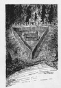
| Date: | 1655 |
|---|---|
| Description: | Front view of the Radisson cabin, the first house built by a white man in Wisconsin. It was built between 1650 and 1660 on Chequamegon Bay, in the vicinity... |

| Date: | 1696 |
|---|---|
| Description: | This sea chart and topographical map depicts the north east coast of Canada and North America, focusing on the Hudson Bay and Great Lakes regions. It shows... |

| Date: | 1698 |
|---|---|
| Description: | A sea chart of Hudson's Bay, Greenland, and the Canadian Arctic. This map shows rhumb lines extending from various points including two compass roses. Coas... |

| Date: | 1675 |
|---|---|
| Description: | This atlas shows the western hemisphere, with a small portion of Spain and Africa. Several place names are labeled, such as the Plymouth colony, settlement... |

| Date: | 1683 |
|---|---|
| Description: | Map of the north east coast of North America showing islands, regions, Native American land, bays, and a few European settlements. The Great Lakes appear i... |

| Date: | 1667 |
|---|---|
| Description: | Map of Virginia depicting the discoveries detailed by John Smith in his exploration of the region. It shows Jamestown, Native American tribes and villages,... |

| Date: | 1671 |
|---|---|
| Description: | Map of Virginia depicting the discoveries detailed by John Smith in his exploration of the region. It shows Jamestown, Native American tribes and villages,... |

| Date: | 1676 |
|---|---|
| Description: | Map of Virginia and Maryland, based on John Smith's 1612 map and Augustine Herman's 1673 seminal map. It shows borders, counties, Native American land, tri... |
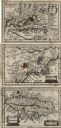
| Date: | 1675 |
|---|---|
| Description: | Three maps found within John Speed's atlas A Prospect of the Most Famous Parts of the World along with the corresponding text. The first map shows V... |
If you didn't find the material you searched for, our Library Reference Staff can help.
Call our reference desk at 608-264-6535 or email us at: