 Filter: Categories of Wisconsin Historical Images
Filter: Year of 1700-1799
Filter: Categories of Wisconsin Historical Images
Filter: Year of 1700-1799
| Date: | 1755 |
|---|---|
| Description: | Dutch map of America and parts of Canada east of the Mississippi based largely on the famous John Mitchell map. It shows rivers, lakes, mountains, settlem... |

| Date: | 1755 |
|---|---|
| Description: | Large format map of America and Canada east of the Mississippi River. D'Anville marks the locations of rivers, lakes, settlements, cities, Native American ... |

| Date: | 1747 |
|---|---|
| Description: | Map of America showing rivers, lakes, mountains, and regions, but primarily focusing on the French and Native American settlements along the Mississippi th... |

| Date: | 1755 |
|---|---|
| Description: | This map shows forts, missions, villages and cities, rivers and portages, and boundaries of the Spanish, English, and French territories, marking the large... |

| Date: | 1788 |
|---|---|
| Description: | This map shows the north western coast of North America, including the southern coast of what will be Alaska and parts of the Aleutian Islands. It includes... |

| Date: | 1770 |
|---|---|
| Description: | The south west sheet of a four sheet map of Virginia, showing the counties, mountains, rivers, court houses, a few cities, and mills. A few Plantations ar... |

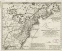
| Date: | 1790 |
|---|---|
| Description: | This map of the north eastern states shows roads, rivers, lakes, waterfalls, mountains, cities, forts, mills, the Oneida Reservation, and "New York Donatio... |

| Date: | 1758 |
|---|---|
| Description: | This detailed map of north eastern America shows the boundaries, cities, mountains, rivers, lakes, Native American land and towns, and roads from east of t... |

| Date: | 1776 |
|---|---|
| Description: | Map of New Jersey and New York, showing cities, forts, roads, counties, townships, land grants, rivers, lakes and several topographical features. Much of t... |

| Date: | 1776 |
|---|---|
| Description: | This was one of the first maps available for the general British populace featuring America during the Revolutionary War. It includes forts, cities, topogr... |

| Date: | 1757 |
|---|---|
| Description: | This map shows the cities, plantations, lakes, rivers, mountains, Native American territories and colonial borders of the Eastern half of North America, pl... |

| Date: | 1786 |
|---|---|
| Description: | One half of a four sheet nautical chart, showing the coastlines of the north-west hemisphere. The interior lands are left bare, even of basic features such... |

| Date: | 1715 |
|---|---|
| Description: | One of Herman Moll's most famous maps, often referred to as The Codfish Map, it shows rivers and portages, cities, Indian villages, wind directions, routes... |

| Date: | 1720 |
|---|---|
| Description: | One of Herman Moll's most famous maps, often referred to as The Beaver Map for its elaborate engraved inset depicting and describing beavers building a dam... |

| Date: | 1710 |
|---|---|
| Description: | A seminal and fairly accurate map of the Great Lakes Region up to Baffin's Bay in Northern Canada. This is possibly the first printed map to locate Detroit... |

| Date: | 1703 |
|---|---|
| Description: | Map of the Golf of Mexico and surrounding countries from the Great Lakes down to the northern most parts of South America. L'Isle labels cities, towns, and... |

| Date: | 1746 |
|---|---|
| Description: | A map of the western hemisphere, including parts of western Europe and Africa, showing the division of the Americas by the European powers. Weapons and fol... |

| Date: | 1721 |
|---|---|
| Description: | A map of North and South America with an elaborately illustrated cartouche depicting Native Americans in upper left corner. The map is fairly detailed, dep... |

| Date: | 1735 |
|---|---|
| Description: | A map of the western hemisphere, including parts of western Europe and Africa. Portraits of explorers, such as Jacques Marquette, Louis Joliet, and Robert ... |

| Date: | 1785 |
|---|---|
| Description: | Map of part of North America engraved and hand-colored (the light brown design is a superposition of the map and cartouche derived from the oxidation of th... |
If you didn't find the material you searched for, our Library Reference Staff can help.
Call our reference desk at 608-264-6535 or email us at: