 Filter: Categories of Wisconsin Historical Images
Filter: Subject of Mines and mineral resources
Filter: Subject of land
Filter: Categories of Wisconsin Historical Images
Filter: Subject of Mines and mineral resources
Filter: Subject of land

| Date: | 1871 |
|---|---|
| Description: | This map shows railroads, canals, towns and some lighthouses. Areas of the company lands proper, tin, iron, gold & silver, silver islet, and lead are color... |

| Date: | 1857 |
|---|---|
| Description: | This map shows lot numbers, lot dimensions (in chains and links), and a mineral reservation for use of proprietors. Includes certifications signed in Sept.... |

| Date: | 1864 |
|---|---|
| Description: | This map is pen and watercolor on paper and shows a profile and the geological formation of Blue Mound. Also shown is the location of Arnold's Hotel and Br... |

| Date: | |
|---|---|
| Description: | A vintage view and a modern view of the zinc works site, presented as a pair. Views include industrial buildings and snow. |
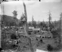
| Date: | 1903 |
|---|---|
| Description: | Elevated view of a mining camp in the western United States. At this time Carl Peterson was writing letters home to Christine Jenson about his journey. |
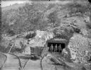
| Date: | 1903 |
|---|---|
| Description: | View down set of two railroad tracks towards four coal miners posing in front of a mine entrance near a coal car. The caption in the book reads, "Strike-br... |

| Date: | 1922 |
|---|---|
| Description: | Elevated view from hill looking down on a mining town surrounded by wooded hills. There are wooden sidewalks between the houses. In the background on the l... |

| Date: | 1782 |
|---|---|
| Description: | Map of the West Indies and south eastern North America, remarkably detailed, showing cities, mountains, rivers, lakes, mines, plantations, forts, banks, an... |

| Date: | 1783 |
|---|---|
| Description: | This map is hand-colored and shows the boundaries of British, Spanish, and the newly recognized American claims, as well as the fishing rights granted to F... |

| Date: | 1866 |
|---|---|
| Description: | A colorful map of Gilpin County, the central gold region of Colorado, surveyed by Charles W. Morse and George Hill. |

| Date: | 1719 |
|---|---|
| Description: | Map of North America showing political boundaries, areas of Indian habitation, cities, towns, ports, rivers, mines, and other notable for North America fro... |

| Date: | 1745 |
|---|---|
| Description: | Landmark map of the Great Lakes region and one of the most advanced depictions of the lakes and surrounding areas for its time. It is the first map to intr... |

| Date: | 1720 |
|---|---|
| Description: | Map of North America from from the Rio Grande to the Atlantic Ocean, showing boundaries, the colonies, cities, settlements, mines, forts, Native American l... |

| Date: | 1765 |
|---|---|
| Description: | Detailed map composed for the London Magazine of the Mississippi River Valley at the conclusion of the French and Indian War. The British colonies themselv... |

| Date: | 1720 |
|---|---|
| Description: | Detailed, ornate, and comprehensive map of America from the east coast to present day Texas. Numerous features appear throughout the map, including Native ... |

| Date: | 1782 |
|---|---|
| Description: | Map of America covering the Rio Grande to the Atlantic Ocean, showing boundaries, the colonies, cities, settlements, Native American lands and villages, m... |

| Date: | 1792 |
|---|---|
| Description: | Map of the United States east of the Mississippi River and north of the Ohio River. It shows the borders between the north eastern states, Canada and the U... |

| Date: | 1794 |
|---|---|
| Description: | Extremely detailed map of the south-eastern states, south from Virginia and east of the Mississippi River. It shows roads and paths, cities, towns, forts, ... |

| Date: | 1795 |
|---|---|
| Description: | Heavily detailed and rare map of the United States. The map features the states, territories, cities, towns, forts, mines, mountains, swamps, lakes, and ri... |

| Date: | 1805 |
|---|---|
| Description: | Map of the United States. It shows the states, cities, towns, Native American land, mountains, lakes, and rivers. Tennessee, Kentucky, and Ohio are labeled... |
If you didn't find the material you searched for, our Library Reference Staff can help.
Call our reference desk at 608-264-6535 or email us at: