Map or Atlas
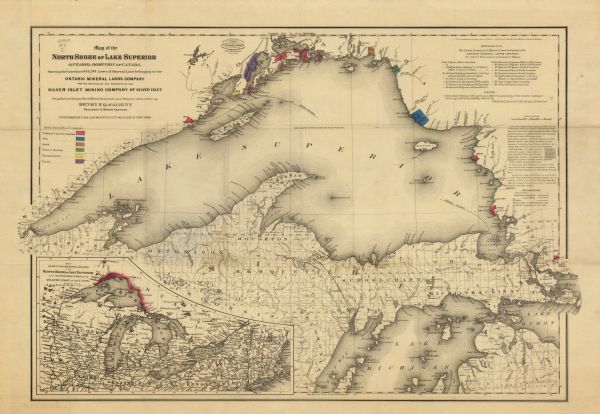
Map of the North Shore of Lake Superior, Ontario, Dominion of Canada : Showing the Location of 94,298 Acres of Mineral Land Belonging to the Ontario Mineral Lands Company and the Position of the Property of the Silver Islet Mining Company of Silver Islet

| This map shows railroads, canals, towns and some lighthouses. Areas of the company lands proper, tin, iron, gold & silver, silver islet, and lead are colored in either red, blue, brown, green, yellow, or purple. A key, notes, and explanations are also included. An inset map shows the geographical relation of the north shore of Lake Superior with the other Great Lakes and the Atlantic coast of the Union. Portions of Minnesota, Wisconsin, Iowa, Illinois, Indiana, Ohio, Pennsylvania, New York, Vermont, Massachusetts, Connecticut, and Ontario are labeled. |
| Image ID: | 116587 |
|---|---|
| Creation Date: | 1871 |
| Creator Name: | Aligny, Henry F. Q. d’ (Henry Ferdinand Quarré) |
| City: | |
| County: | |
| State: | Wisconsin |
| Collection Name: | Map Collection |
| Genre: | Map or Atlas |
| Original Format Type: | prints, photomechanical |
| Original Format Number: | H GX909 1871 C |
| Original Dimensions: | 39 x 62 cm., on sheet 46 x 67 cm. |
| Mines and mineral resources |
| Apostle Islands (Wis.) |
| Canals |
| Railroads |
| Lakes |
| Michigan, Lake |
| Superior, Lake |
| Cities and towns |
| This image is issued by the Wisconsin Historical Society. Use of the image requires written permission from the staff of the Collections Division. It may not be sold or redistributed, copied or distributed as a photograph, electronic file, or any other media. The image should not be significantly altered through conventional or electronic means. Images altered beyond standard cropping and resizing require further negotiation with a staff member. The user is responsible for all issues of copyright. Please Credit: Wisconsin Historical Society. |
| Location: | Wisconsin Historical Society Archives, 4th Floor, Madison, Wisconsin |
|---|
