Filter: Categories of Wisconsin Historical Images
Filter: Subject of Marshes
Filter: Subject of botany
Filter: Categories of Wisconsin Historical Images
Filter: Subject of Marshes
Filter: Subject of botany

| Date: | 06 30 1895 |
|---|---|
| Description: | A man is standing in the right foreground near a tall plant, perhaps corn. In the center is a square-shaped pond with high banks. A man is in the backgroun... |

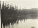
| Date: | |
|---|---|
| Description: | Elevated view from a hill of a lake or river surrounded by fields and hills. The water is either marshy, or has been flooded, as trees and plants are growi... |
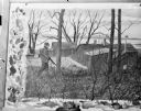
| Date: | |
|---|---|
| Description: | Photograph of a framed watercolor painting of a hunter walking in tall grass among trees by the Johnson duck shack at old Cherokee Marsh. |

| Date: | |
|---|---|
| Description: | View of Johnson duck shack at old Cherokee Marsh amidst trees and shrubs. The site was where plans for the Ducks Unlimited southern Wisconsin chapter were ... |

| Date: | 1755 |
|---|---|
| Description: | This map shows the eastern half of North America during the French and Indian war, including cities, borders, Native American Land, forts, and detailed geo... |

| Date: | |
|---|---|
| Description: | A long, narrow pen-and-ink image with a series of ducks in progressive order as they take off and land over a marsh. |

| Date: | 1795 |
|---|---|
| Description: | Map of Connecticut showing counties, townships, cities, roads, islands, swamps, hills, mountains, lakes, rivers, reefs, and numerous other geographical and... |

| Date: | 1756 |
|---|---|
| Description: | Map of Pennsylvania, showing cities, towns, roads, trading paths, portages, forts, mountains, swamps, waterfalls, lakes, and rivers. The map further includ... |

| Date: | 1784 |
|---|---|
| Description: | Map of the southeastern region of America to just west of the Mississippi River. It shows borders, cities, towns, forts, Native American land, portages, mo... |

| Date: | 1676 |
|---|---|
| Description: | Map of Virginia and Maryland, based on John Smith's 1612 map and Augustine Herman's 1673 seminal map. It shows borders, counties, Native American land, tri... |

| Date: | 1776 |
|---|---|
| Description: | Map of Virginia and parts of Maryland and Delaware (written "De La War"). It shows borders, counties, cities, towns, plantations (marked by landowners name... |

| Date: | 1779 |
|---|---|
| Description: | Map of South Carolina showing boundary lines, Native American land, precincts, townships, cities, towns, forts, roads, mountains, hills, swamps, islands, a... |

| Date: | |
|---|---|
| Description: | Watercolor painting of a hunter walking in tall grass among trees by the Johnson duck shack at old Cherokee Marsh. |

| Date: | 1779 |
|---|---|
| Description: | Map of colonial Georgia showing cities, towns, Native American land and towns, forts, roads, trading paths, islands, mountains, swamps, and rivers. Annotat... |

| Date: | 1765 |
|---|---|
| Description: | Map showing the new British territories of East and West Florida following the Treaty of Paris at the end of the French and Indian War. It shows boundaries... |

| Date: | 1761 |
|---|---|
| Description: | Map covering southern Louisiana from Lake Ponchetrain to the Golf of Mexico and from Woods Bay in the west to the islands just east of Bay St. Louis. It sh... |

| Date: | 1766 |
|---|---|
| Description: | Map of the region south of Lake Erie to the Ohio River. It shows forts, towns, Native American towns, mines, roads, mountains, swamps, lakes, and rivers. T... |
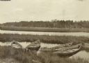
| Date: | 1907 |
|---|---|
| Description: | Four boats are partially submerged in shallow water by the St. Croix River. |

| Date: | 08 1916 |
|---|---|
| Description: | Elevated view looking down at a canoe on the shoreline of the Chippewa River as The Gang takes a well-earned rest. |
If you didn't find the material you searched for, our Library Reference Staff can help.
Call our reference desk at 608-264-6535 or email us at: