 Filter: Categories of Wisconsin Historical Images
Filter: Subject of Exploration
Filter: Subject of transportation
Filter: Categories of Wisconsin Historical Images
Filter: Subject of Exploration
Filter: Subject of transportation
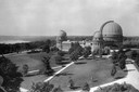
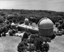
| Date: | 1935 |
|---|---|
| Description: | Elevated exterior view of Yerkes Observatory. Geneva Lake is in the background, left. Roads and sidewalks cross the sweeping, well tended lawns. The desi... |

| Date: | 1823 |
|---|---|
| Description: | In 1823 U.S. Army major Stephen H. Long led an expedition of scientific, trade, and military investigation up the Mississippi River and the Red River of th... |
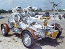
| Date: | 09 1972 |
|---|---|
| Description: | Astronauts Eugene Cernan and Harrison Schmitt practice operating the lunar roving vehicle (LRV) in preparation for the Apollo 17 mission to the moon. They ... |
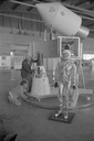
| Date: | 1965 |
|---|---|
| Description: | A traveling display about the NASA manned space program on exhibit at Austin Straubel Airport. Included in the exhibit is a model of a space capsule and a ... |
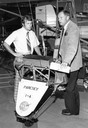
| Date: | |
|---|---|
| Description: | Astronaut Neil Armstrong (right), the first man to walk on the surface of the Moon, with Tom Poberezny, the son of EAA founder Paul Poberezny and the presi... |

| Date: | 1893 |
|---|---|
| Description: | Front and back covers of an advertising brochure for the New Empire line of mowers, reapers and grain binders manufactured by J.F. Seiberling & Company. Th... |
| Date: | 1950 |
|---|---|
| Description: | Bird's-eye view of Yerkes Observatory. |
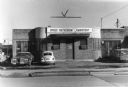
| Date: | 03 18 1973 |
|---|---|
| Description: | Exterior view of the University of Wisconsin Space Astronomy Laboratory at 35 North Park Street. |

| Date: | 1855 |
|---|---|
| Description: | Map reads "Our Country" which is accompanied by a sailor with a flag to the left and workers rejoicing under the Constitution and Laws to the right. Across... |

| Date: | 1836 |
|---|---|
| Description: | This map depicts Wisconsin and Michigan territories in 1836. It includes the area from Michigan to the Missouri River and Lake Winnipeg, and it shows the e... |
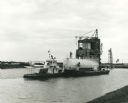
| Date: | 1967 |
|---|---|
| Description: | NASA towboat, the "Clermont", pulling a liquid oxygen tank in the canal system of the Mississippi Test Support Department. Original caption reads (in part)... |

| Date: | 1710 |
|---|---|
| Description: | A seminal and fairly accurate map of the Great Lakes Region up to Baffin's Bay in Northern Canada. This is possibly the first printed map to locate Detroit... |

| Date: | 1786 |
|---|---|
| Description: | One half of a four sheet nautical chart, showing the coastlines of the north-west hemisphere. The interior lands are left bare, even of basic features such... |

| Date: | 1696 |
|---|---|
| Description: | This sea chart and topographical map depicts the north east coast of Canada and North America, focusing on the Hudson Bay and Great Lakes regions. It shows... |

| Date: | 1783 |
|---|---|
| Description: | This map is hand-colored and shows the boundaries of British, Spanish, and the newly recognized American claims, as well as the fishing rights granted to F... |
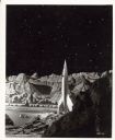
| Date: | |
|---|---|
| Description: | Still from the film 1950 film "Destination Moon." The rocket ship is sitting on the lunar landscape. |

| Date: | 1556 |
|---|---|
| Description: | One of the earliest obtainable maps to accurately (for its time) depict the Americas, this map shows more decorative than descriptive features. A few river... |

| Date: | 1679 |
|---|---|
| Description: | Decorative and detailed map of the eastern half of North America. Regions, cities, colonies, Native America land, rivers, lakes and some nautical features ... |

| Date: | 1685 |
|---|---|
| Description: | A detailed map of the western hemisphere showing cities, settlements, Native American land, rivers, lakes, mountains, the Great Lakes, and California as an... |

| Date: | 1684 |
|---|---|
| Description: | Map of North America showing some colonies, cities, rivers, lakes, and Native American land. Ship routes spread across both oceans, including one decorated... |
If you didn't find the material you searched for, our Library Reference Staff can help.
Call our reference desk at 608-264-6535 or email us at: