 Filter: Categories of Wisconsin Historical Images
Filter: Subject of Engraving
Filter: Subject of botany
Filter: Subject of mississippi river
Filter: Categories of Wisconsin Historical Images
Filter: Subject of Engraving
Filter: Subject of botany
Filter: Subject of mississippi river

| Date: | |
|---|---|
| Description: | Drawing of Grand Turk steamboat on the river's edge. Print is part of a series collected in Lewis' "Das Illustririte Mississippithal". |

| Date: | |
|---|---|
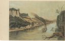
| Description: | Drawing of the mouth of the Wisconsin River from a scenic overlook depicting a steamboat in the distance. Print is part of a series collected in Lewis' "Da... |
| Date: | |
|---|---|
| Description: | Drawing of Savannah, Illinois, depicting a small town along the shore of the Mississippi River. There is a steamboat in the foreground. Print is part of a ... |

| Date: | |
|---|---|
| Description: | Lithographed drawing of the mouth of the St. Croix River depicting a sailing barge and steamboat in the distance. Print is part of a series collected in Le... |

| Date: | |
|---|---|
| Description: | Drawing of the rapids on the Mississippi River depicting several steamboats in the distance. Print is part of a series collected in Lewis' "Das Illustririt... |

| Date: | 04 05 1862 |
|---|---|
| Description: | Engraved illustration for the story titled: "The Fight at Island No. 10". The view from the deck of a boat looks out at the approaching gun boats coming do... |
| Date: | 1874 |
|---|---|
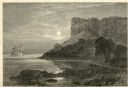
| Description: | Engraved view of Maiden's Rock at Lake Pepin. A steamboat is on the Mississippi River. |

| Date: | 1783 |
|---|---|
| Description: | This map is hand-colored and shows the boundaries of British, Spanish, and the newly recognized American claims, as well as the fishing rights granted to F... |

| Date: | 1755 |
|---|---|
| Description: | Map of North America east of the Mississippi River showing cities, settlements, Native American land, mountains, lakes, rivers, and the boundaries between ... |

| Date: | 1776 |
|---|---|
| Description: | Map of the American colonies and land east of the Mississippi River. Prominent cities, forts, Native American land, mountains, rivers and lakes are all sho... |

| Date: | 1770 |
|---|---|
| Description: | Map of North America showing the boundaries between French, Spanish, and English claims after the French and Indian War. Kitchin includes numerous place na... |

| Date: | 1755 |
|---|---|
| Description: | Map of colonial America, showing the lands north of South Carolina and west of the Mississippi River. An inset map of the Carolinas and Georgia sits in the... |

| Date: | 1720 |
|---|---|
| Description: | Detailed, ornate, and comprehensive map of America from the east coast to present day Texas. Numerous features appear throughout the map, including Native ... |

| Date: | 1784 |
|---|---|
| Description: | Map of the southeastern region of America to just west of the Mississippi River. It shows borders, cities, towns, forts, Native American land, portages, mo... |

| Date: | 1760 |
|---|---|
| Description: | Map showing the towns, mountains, valleys, corn fields, and rivers of a portion of the Cherokee Nation. A few annotations on the map explain the land and r... |

| Date: | 1761 |
|---|---|
| Description: | Map covering southern Louisiana from Lake Ponchetrain to the Golf of Mexico and from Woods Bay in the west to the islands just east of Bay St. Louis. It sh... |
If you didn't find the material you searched for, our Library Reference Staff can help.
Call our reference desk at 608-264-6535 or email us at:
