 Filter: Categories of Wisconsin Historical Images
Filter: FORMAT_TYPE of prints, fine-art
Filter: Subject of flowers
Filter: Categories of Wisconsin Historical Images
Filter: FORMAT_TYPE of prints, fine-art
Filter: Subject of flowers

| Date: | 1963 |
|---|---|
| Description: | Cover for the Wisconsin Friends of Our Native Landscape program. Depicted is a bright green and pink Jack-in-the-pulpit. The Wisconsin Friends chapter was ... |

| Date: | 1969 |
|---|---|
| Description: | Cover for the 1969 Wisconsin Friends of Our Native Landscape program. Depicted is a tree with white blossoms, yellow flowers, and a pathway leading up to a... |

| Date: | 1960 |
|---|---|
| Description: | Cover for the 1960 Wisconsin Friends of Our Native Landscape program. Depicted are some vibrant purple flowers, with a lake in the background. The Wisconsi... |

| Date: | 1966 |
|---|---|
| Description: | Cover for the 1966 Wisconsin Friends of Our Native Landscape program. Depicted are two pink lady slipper orchids. The Wisconsin Friends chapter was founded... |

| Date: | 1956 |
|---|---|
| Description: | Cover for the 1956 Wisconsin Friends of Our Native Landscape program. Depicted are some white flowers with green leaves, a lake, and some birds flying in t... |

| Date: | |
|---|---|
| Description: | Print advocating "Unconditional and Universal Amnesty". Includes an image of a flower in a rifle. |

| Date: | 1975 |
|---|---|
| Description: | Composited silk screen images including seashells, flowers, rock formation, rolling pins and a human skull. Poster is promoting the work of Tom Hunt and Ti... |
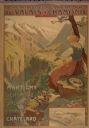
| Date: | 1900 |
|---|---|
| Description: | An original colored lithograph advertising the Chemins de Fer électrique du Valais à Chamonix (Electric Railways of Valais in Chamonix) railway. The poster... |

| Date: | 1860 |
|---|---|
| Description: | A soldier stands on the left with his gun and bayonet. A sailor stands on the right holding a banner that reads, "THE UNION MUST & SHALL BE PRESERVED." In ... |

| Date: | 1840 |
|---|---|
| Description: | Valentine's Day card with flowers and gold and white flourishes. Text at bottom reads: "Ever Thine." It has been mounted to a piece of paper and a silhouet... |

| Date: | 1895 |
|---|---|
| Description: | Valentine's Day card with three layers. The bottom layer is a pink and white card with embossed floral designs. The middle layer (not visible) is a country... |

| Date: | 1927 |
|---|---|
| Description: | Blueprint-style map of Frost Woods on the shore of Lake Monona. The map indicates the locations of Indian mounds, an Indian camp, and various plants. There... |

| Date: | 1780 |
|---|---|
| Description: | This map portrays North and South America at a very unusual angle, with north oriented towards the upper right corner. Colonies, Native American land, a fe... |

| Date: | 1759 |
|---|---|
| Description: | Map of North and South America showing regions, colonies, cities and settlements, rivers, lakes, and Native American land. Near the bottom left an inset ma... |

| Date: | 1763 |
|---|---|
| Description: | Map of America and part of Canada including the borders of European claims after the French and Indian War. Cities, forts, Native American lands, rivers, l... |

| Date: | 1755 |
|---|---|
| Description: | Map of colonial America, showing the lands north of South Carolina and west of the Mississippi River. An inset map of the Carolinas and Georgia sits in the... |

| Date: | 1780 |
|---|---|
| Description: | Detailed map of America east of the Louisiana region. It shows forts, cities, borders and boundary lines, Native American land, the post road, mountains, w... |

| Date: | 1795 |
|---|---|
| Description: | Map of Connecticut showing counties, townships, cities, roads, islands, swamps, hills, mountains, lakes, rivers, reefs, and numerous other geographical and... |

| Date: | 1784 |
|---|---|
| Description: | Map of the southeastern region of America to just west of the Mississippi River. It shows borders, cities, towns, forts, Native American land, portages, mo... |

| Date: | 1776 |
|---|---|
| Description: | Map of Virginia and parts of Maryland and Delaware (written "De La War"). It shows borders, counties, cities, towns, plantations (marked by landowners name... |
If you didn't find the material you searched for, our Library Reference Staff can help.
Call our reference desk at 608-264-6535 or email us at: