 Filter: Categories of Wisconsin Historical Images
Filter: Year of 1700-1799
Filter: Categories of Wisconsin Historical Images
Filter: Year of 1700-1799

| Date: | 1799 |
|---|---|
| Description: | Map of Rhode Island showing counties, townships, cities, roads, mountains, swamps, islands, reefs, lakes and rivers. Several of the bigger cities include s... |

| Date: | 1780 |
|---|---|
| Description: | Map of Connecticut, Rhode Island, and Long Island. it shows the borders, cities, roads, islands, mountains, lakes and rivers. Navigational hazards along th... |

| Date: | 1795 |
|---|---|
| Description: | Map of Massachusetts showing counties, cities, roads, islands (including Nantucket and Martha's Vineyard), mountains, hills, lakes, and rivers. Two small e... |

| Date: | 1795 |
|---|---|
| Description: | Map of Vermont showing counties, townships, cities, roads, mountains, lakes, and rivers. A forest and waterfall scene decorates the title cartouche in the ... |
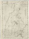
| Date: | 1791 |
|---|---|
| Description: | Detailed map of New Hampshire. It shows counties, cities, mountains, highlands, lakes, and rivers. The acres given to Dartmouth College are labeled far in ... |

| Date: | 1795 |
|---|---|
| Description: | Map of Maine, showing a few cities, harbors, hills, mountains, lakes, and rivers. A road runs from Pownalboro south to Portsmouth harbor, and the boundary ... |

| Date: | 1780 |
|---|---|
| Description: | Map of eastern Massachusetts, Rhode Island, eastern Connecticut, and small portions of New Hampshire and Vermont. It shows the boundaries, counties, citie... |

| Date: | 1775 |
|---|---|
| Description: | Map of Boston and surrounding regions, from Massachusetts Bay to the Connecticut River, and including part of southern New Hampshire. It shows the colonies... |

| Date: | 1755 |
|---|---|
| Description: | Map of New England, with three inset maps of Fort Oswego, Fort du Quesne, and Fort Frederick. It shows colonies, a few cities, forts (marked as French or E... |

| Date: | 1781 |
|---|---|
| Description: | Map of New Hampshire and surrounding regions. It shows borders, regions, cities, numerous forts, the country of the Iroquois, mountains, rivers, and lakes.... |

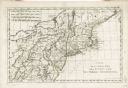
| Date: | 1796 |
|---|---|
| Description: | Map of the United Sates, showing the borders between the states and territories, a few cities, mountains, portages, waterfalls, lakes, and rivers. Tennesse... |

| Date: | 1795 |
|---|---|
| Description: | Heavily detailed and rare map of the United States. The map features the states, territories, cities, towns, forts, mines, mountains, swamps, lakes, and ri... |

| Date: | 1795 |
|---|---|
| Description: | Map of the United States east of the Mississippi River. It features roads, cities, towns, early settlements, Native American land, forts, mountains, rivers... |

| Date: | 1794 |
|---|---|
| Description: | Extremely detailed map of the south-eastern states, south from Virginia and east of the Mississippi River. It shows roads and paths, cities, towns, forts, ... |

| Date: | 1792 |
|---|---|
| Description: | Map of the United States east of the Mississippi River and north of the Ohio River. It shows the borders between the north eastern states, Canada and the U... |

| Date: | 1794 |
|---|---|
| Description: | Map of the United States east of the Mississippi River. It shows borders, treaty lines, forts, cities, towns, Native American land, mountains, swamps, lake... |
| Date: | 1783 |
|---|---|
| Description: | Map of the north east coast of the United States, north of Virginia and east of Lake Erie. It shows the states, forts, cities, towns, mountains, Niagara Fa... |

| Date: | 1782 |
|---|---|
| Description: | Map of America covering the Rio Grande to the Atlantic Ocean, showing boundaries, the colonies, cities, settlements, Native American lands and villages, m... |

| Date: | 1780 |
|---|---|
| Description: | Detailed map of America east of the Louisiana region. It shows forts, cities, borders and boundary lines, Native American land, the post road, mountains, w... |

| Date: | 1720 |
|---|---|
| Description: | Detailed, ornate, and comprehensive map of America from the east coast to present day Texas. Numerous features appear throughout the map, including Native ... |
If you didn't find the material you searched for, our Library Reference Staff can help.
Call our reference desk at 608-264-6535 or email us at: