A Map of the Western Part of the Territories Belonging to the United States of America: Drawn from the Best Authorities | Map or Atlas | Wisconsin Historical Society

Map or Atlas

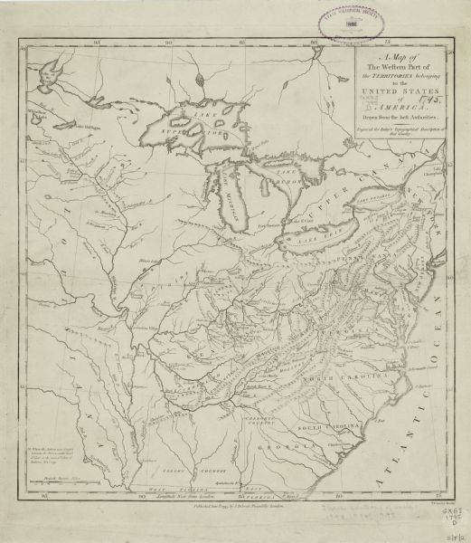
A Map of the Western Part of the Territories Belonging to the United States of America: Drawn from the Best Authorities
A Map of the Western Part of the Territories Belonging to the United States of America: Drawn from the Best Authorities | Map or Atlas | Wisconsin Historical Society
Map of the United States east of the Mississippi River. It features roads, cities, towns, early settlements, Native American land, forts, mountains, rivers, and lakes. Of more importance, the map highlights the Blackberry Campaign of the Northwest Indian War. The routes of James Wilkinson and Charles Scott appear as dotted lines in the Kentucky region. A crossed swords icon at the edge of the Salamine River marks the location where, according the the annotation in the lower left corner "action was fought between the forces under Genl. St. Clair & the united Tribes of Indians, Novr. 1791."
DESCRIPTION
Map of the United States east of the Mississippi River. It features roads, cities, towns, early settlements, Native American land, forts, mountains, rivers, and lakes. Of more importance, the map highlights the Blackberry Campaign of the Northwest Indian War. The routes of James Wilkinson and Charles Scott appear as dotted lines in the Kentucky region. A crossed swords icon at the edge of the Salamine River marks the location where, according the the annotation in the lower left corner "action was fought between the forces under Genl. St. Clair & the united Tribes of Indians, Novr. 1791."
RECORD DETAILS
Image ID:124383
Creation Date: 1795
Creator Name:Conder, Thomas
City:
County:
State:
Collection Name:Map Collection
Genre:Map or Atlas
Original Format Type:prints, fine-art
Original Format Number:H GX83 1795 D
Original Dimensions:34 x 32 cm
ADDITIONAL INFORMATION
Appears in Gilbert Implay's Topographical Description of the Western Territory of North America.
SUBJECTS
Engraving
Cities and towns
Maps
Mountains
Battles
War
Lakes
Mississippi River
Rivers

How to Purchase a Copy

Buy The Image

For commercial or non-profit use, please contact Image Sales.

By clicking "BUY" you agree to our Terms of Use.

10-percent discount for Society Members.

Image-purchasing questions? Please Contact Us.

RIGHTS AND PERMISSIONS
This image is issued by the Wisconsin Historical Society. Use of the image requires written permission from the staff of the Collections Division. It may not be sold or redistributed, copied or distributed as a photograph, electronic file, or any other media. The image should not be significantly altered through conventional or electronic means. Images altered beyond standard cropping and resizing require further negotiation with a staff member. The user is responsible for all issues of copyright. Please Credit: Wisconsin Historical Society.
Reference Details
Location:Wisconsin Historical Society Archives, 4th Floor, Madison, Wisconsin

How to View in Person

To view this image, visit the Archives Research Room on the 4th floor at the Society Headquarters building in Madison, WI. Print out this index page and present it to the librarian. Use the links below to plan your visit to the Society's Archives.

Checking Out Materials

Visual materials in the Archives do not circulate and must be viewed in the Society's Archives Research Room.

How to Cite

For the purposes of a bibliography entry or footnote, follow this model:

Wisconsin Historical Society Citation
Wisconsin Historical Society, Creator, Title, Image ID. Viewed online at (copy and paste image page link).
Wisconsin Center for Film and Theater Research Citation
Wisconsin Center for Film and Theater Research, Creator, Title, Image ID. Viewed online at (copy and paste image page link).

Have Questions?

Contact our Archives staff by email.