 Filter: Categories of Wisconsin Historical Images
Filter: Subject of indians of north america
Filter: Subject of war
Filter: Categories of Wisconsin Historical Images
Filter: Subject of indians of north america
Filter: Subject of war
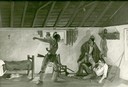
| Date: | 1940 |
|---|---|
| Description: | Photograph of a painting by Cal Peters depicting the Winnebago attack on the Gagnier homestead in 1827 and the killing of Registre Gagnier. The homestead w... |
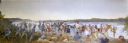
| Date: | |
|---|---|
| Description: | Painting by Cal Peters depicting the battle of Bad Axe, also known as the Bad Axe massacre, at the Mississippi River on August 2, 1832. |

| Date: | 1852 |
|---|---|
| Description: | Illustration of the Ojibwa, the Sacs, and Foxes battling from canoes on the water. |
| Date: | |
|---|---|
| Description: | Portrait of Modoc Captain Jack, leader in the Modoc War. |

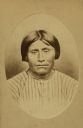
| Date: | |
|---|---|
| Description: | Portrait of Modoc Chief Winema, who saved the life of Colonel Meacham in the Modoc War. |
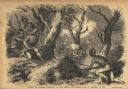
| Date: | 01 07 1855 |
|---|---|
| Description: | Sketch of the defeat of General Braddock during an ambush in the French and Indian War. Caption reads: "Defeat of General Braddock, in the French and India... |
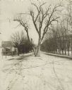
| Date: | |
|---|---|
| Description: | The Black Hawk Tree growing in the middle of the street, now East Black Hawk Avenue. There are houses on the left and the road is lined with trees planted... |
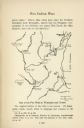
| Date: | |
|---|---|
| Description: | Hand-drawn map of the location of the Fox Indian Wars. |
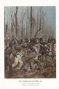
| Date: | 1982 |
|---|---|
| Description: | "The painting shows the Choctaws and a mixed group of Major Daquin's Battalion of Free Men of Color. The latter were mostly attired in civilian clothes bec... |

| Date: | |
|---|---|
| Description: | A map of southern Wisconsin and northern Illinois showing where the battles took place and routes taken by Black Hawk and his band during the Black Hawk Wa... |

| Date: | |
|---|---|
| Description: | Sixth plate daguerreotype of Col. Jeremiah Austill of Alabama as an older man. Austill fought in the Creek War in Alabama and Georgia, from 1813-14. After ... |

| Date: | 1998 |
|---|---|
| Description: | This map shows an auto tour route with historical markers and the approximate Black Hawk Band route in southern Wisconsin. County boundaries, roads and cit... |

| Date: | 1758 |
|---|---|
| Description: | This detailed map of north eastern America shows the boundaries, cities, mountains, rivers, lakes, Native American land and towns, and roads from east of t... |

| Date: | 1758 |
|---|---|
| Description: | Map showing lakes, rivers, cities, Native American land, and the boundaries of French and English claims in America and Canada north of New York. A title c... |

| Date: | 1755 |
|---|---|
| Description: | Map of colonial America, showing the lands north of South Carolina and west of the Mississippi River. An inset map of the Carolinas and Georgia sits in the... |

| Date: | 1777 |
|---|---|
| Description: | Map of Colonial America east of Lake Michigan showing regions, cities, forts, Native American land, mountains, lakes, and rivers. Crossed swords and small ... |

| Date: | 1795 |
|---|---|
| Description: | Map of the United States east of the Mississippi River. It features roads, cities, towns, early settlements, Native American land, forts, mountains, rivers... |

| Date: | 1755 |
|---|---|
| Description: | Map of New England, with three inset maps of Fort Oswego, Fort du Quesne, and Fort Frederick. It shows colonies, a few cities, forts (marked as French or E... |

| Date: | 1760 |
|---|---|
| Description: | Map showing upstate New York, Lake Ontario, and the St. Lawrence River during the last, decisive battle of the French and Indian War. The main map shows a ... |
If you didn't find the material you searched for, our Library Reference Staff can help.
Call our reference desk at 608-264-6535 or email us at: