Filter: Categories of Wisconsin Historical Images
Filter: Subject of indians of north america
Filter: Subject of flowers
Filter: Categories of Wisconsin Historical Images
Filter: Subject of indians of north america
Filter: Subject of flowers

| Date: | 1655 |
|---|---|
| Description: | Frontispiece to Newe Welt vnd americanische Historien (1655). |

| Date: | |
|---|---|
| Description: | Studio portrait of two young Ho-Chunk men posing sitting and wearing suits and ties in front of a painted backdrop. The young man on the right wearing the ... |

| Date: | |
|---|---|
| Description: | Studio portrait of two young Ho-Chunk men posing standing in front of a painted backdrop. The man on the left is wearing a sweater and suit jacket and is r... |

| Date: | 1900 |
|---|---|
| Description: | Full-length studio portrait of two young Ho-Chunk men posing in front of a painted backdrop. The man on the right is sitting, and the man on the left is st... |
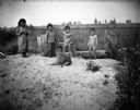
| Date: | |
|---|---|
| Description: | Standing together in a row are two Ho-Chunk girls wearing print dresses, and two Ho-Chunk boys who are nude on a sandy pile in front of a marsh. In front o... |
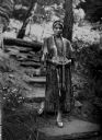
| Date: | |
|---|---|
| Description: | View of a Winnebago (Ho-Chunk) Indian woman in traditional dress. The woman stands on stone steps, surrounded by flowers and trees. |

| Date: | 1981 |
|---|---|
| Description: | Holiday card with the Christ child in a manger surrounded by four praying children, each of a different race, Native American, African American, Caucasian ... |

| Date: | 1927 |
|---|---|
| Description: | Blueprint-style map of Frost Woods on the shore of Lake Monona. The map indicates the locations of Indian mounds, an Indian camp, and various plants. There... |

| Date: | 1780 |
|---|---|
| Description: | This map portrays North and South America at a very unusual angle, with north oriented towards the upper right corner. Colonies, Native American land, a fe... |

| Date: | 1759 |
|---|---|
| Description: | Map of North and South America showing regions, colonies, cities and settlements, rivers, lakes, and Native American land. Near the bottom left an inset ma... |

| Date: | 1763 |
|---|---|
| Description: | Map of America and part of Canada including the borders of European claims after the French and Indian War. Cities, forts, Native American lands, rivers, l... |

| Date: | 1755 |
|---|---|
| Description: | Map of colonial America, showing the lands north of South Carolina and west of the Mississippi River. An inset map of the Carolinas and Georgia sits in the... |

| Date: | 1780 |
|---|---|
| Description: | Detailed map of America east of the Louisiana region. It shows forts, cities, borders and boundary lines, Native American land, the post road, mountains, w... |

| Date: | 1784 |
|---|---|
| Description: | Map of the southeastern region of America to just west of the Mississippi River. It shows borders, cities, towns, forts, Native American land, portages, mo... |

| Date: | |
|---|---|
| Description: | Group portrait of five people at a high school graduation. The graduate is wearing a blanket with a Native American motif draped over one of her shoulders,... |

| Date: | 1910 |
|---|---|
| Description: | Text on front reads: "Winnebago Indians at Bethesda Park, Waukesha, Wis." A group of Ho-Chunk pose at Bethesda Park as a crowd of tourists looks on. There ... |
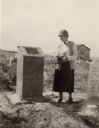
| Date: | 1926 |
|---|---|
| Description: | A woman holding flowers is standing between two graves, looking at the one on the left. Caption reads: "Wind River Indian Reservation (formerly the Shosho... |
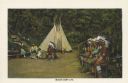
| Date: | 1936 |
|---|---|
| Description: | Text reads: "Indian Camp Life." One of 16 postcard images inside of a souvenir view folder. Four Native American men are sitting on a bench on the right. T... |
If you didn't find the material you searched for, our Library Reference Staff can help.
Call our reference desk at 608-264-6535 or email us at: