 Filter: Categories of Wisconsin Historical Images
Filter: Subject of Science
Filter: Subject of transportation
Filter: Categories of Wisconsin Historical Images
Filter: Subject of Science
Filter: Subject of transportation

| Date: | |
|---|---|
| Description: | Faye Geise, wearing a bikini, is standing and posing with the Aqua Form on her head. |

| Date: | 1710 |
|---|---|
| Description: | A seminal and fairly accurate map of the Great Lakes Region up to Baffin's Bay in Northern Canada. This is possibly the first printed map to locate Detroit... |

| Date: | 1786 |
|---|---|
| Description: | One half of a four sheet nautical chart, showing the coastlines of the north-west hemisphere. The interior lands are left bare, even of basic features such... |

| Date: | 1696 |
|---|---|
| Description: | This sea chart and topographical map depicts the north east coast of Canada and North America, focusing on the Hudson Bay and Great Lakes regions. It shows... |

| Date: | 1783 |
|---|---|
| Description: | This map is hand-colored and shows the boundaries of British, Spanish, and the newly recognized American claims, as well as the fishing rights granted to F... |
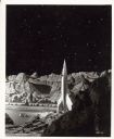
| Date: | |
|---|---|
| Description: | Still from the film 1950 film "Destination Moon." The rocket ship is sitting on the lunar landscape. |

| Date: | 1556 |
|---|---|
| Description: | One of the earliest obtainable maps to accurately (for its time) depict the Americas, this map shows more decorative than descriptive features. A few river... |

| Date: | 1679 |
|---|---|
| Description: | Decorative and detailed map of the eastern half of North America. Regions, cities, colonies, Native America land, rivers, lakes and some nautical features ... |

| Date: | 1685 |
|---|---|
| Description: | A detailed map of the western hemisphere showing cities, settlements, Native American land, rivers, lakes, mountains, the Great Lakes, and California as an... |

| Date: | 1684 |
|---|---|
| Description: | Map of North America showing some colonies, cities, rivers, lakes, and Native American land. Ship routes spread across both oceans, including one decorated... |

| Date: | 1713 |
|---|---|
| Description: | Map showing the regions explored by Robert de La Salle between 1681 and 1686, as well as the route La Salle, and later Henri Joutel, took, moving north fro... |

| Date: | 1775 |
|---|---|
| Description: | This six sheet large format map is one of the most informative maps of its time. It shows cities, Native American land, lakes, rivers, mountains, topograph... |

| Date: | 1759 |
|---|---|
| Description: | Map of north eastern Canada and parts of New England, showing settlements, cities, portages, Native American land, mountains, lakes, and rivers. The unusua... |

| Date: | 1718 |
|---|---|
| Description: | Map of the Southern portion of North America from New Mexico to Florida and south from Lake Erie. It shows borders, cities, settlements, Native American la... |

| Date: | 1720 |
|---|---|
| Description: | Detailed, ornate, and comprehensive map of America from the east coast to present day Texas. Numerous features appear throughout the map, including Native ... |

| Date: | 1782 |
|---|---|
| Description: | Map of America covering the Rio Grande to the Atlantic Ocean, showing boundaries, the colonies, cities, settlements, Native American lands and villages, m... |

| Date: | 08 10 2008 |
|---|---|
| Description: | Underwater view of the wrecked scow schooner Silver Lake. The ship remains largely intact, but it is split in half where it was run over by the P... |

| Date: | 1969 |
|---|---|
| Description: | Bushel baskets of apples on display at a farm stand. Gourds, squash and pumpkins are sitting on a table built around a tree. People are standing in or arou... |
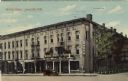
| Date: | 1911 |
|---|---|
| Description: | View from intersection towards a hotel on the corner, with an electric sign. An automobile is parked at the curb, and a public scale is on the sidewalk. Ca... |

| Date: | 08 09 1927 |
|---|---|
| Description: | A man is sitting in the driver's seat of an open truck loaded with grain on a scale at a weigh station. A man is standing near a small building holding the... |
If you didn't find the material you searched for, our Library Reference Staff can help.
Call our reference desk at 608-264-6535 or email us at: