 Filter: Categories of Wisconsin Historical Images
Filter: Subject of Military camps
Filter: Reproduction Rights of For Sale
Filter: Subject of arts
Filter: Categories of Wisconsin Historical Images
Filter: Subject of Military camps
Filter: Reproduction Rights of For Sale
Filter: Subject of arts
| Date: | 1861 |
|---|---|
| Description: | Christmas and New Years greeting card from Hosea W. Rood, presumably sent to his comrades of the 12th Wisconsin Volunteer Infantry, Company E, who had been... |
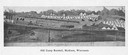
| Date: | 1876 |
|---|---|
| Description: | Quite possibly this is the "General view in the camp" listed in the "Centennial Views of the City of Madison, July 4th, 1876. Views of Chicago Light Guard"... |
| Date: | |
|---|---|
| Description: | A formation of uniformed men holding musical instruments in a field at Camp Devens, established in 1917. |
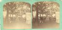
| Date: | 1880 |
|---|---|
| Description: | A composite drawing, including photographic portraits, depicting "Doc" Aubrey, newsboy of the Iron Brigade, delivering papers to the camp where other membe... |
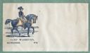
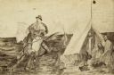
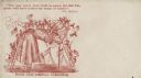
| Date: | 1860 |
|---|---|
| Description: | A soldier rides a horse with a military camp in the background. Caption below reads, "CAMP WASHBURN, MILWAUKEE - - WIS." Blue ink on beige envelope, image ... |
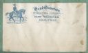
| Date: | 1860 |
|---|---|
| Description: | A cavalry soldier on a horse appears on left, a military camp is seen in the background. To the right in fancy type: "Head Quarters, 2D REGT. WIS. CAVAL... |
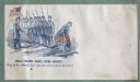
| Date: | 1860 |
|---|---|
| Description: | A rare "risque" (for the time) design. A row of soldiers look away from their officer at a young lady as she lifts her skirts to step over a puddle, exposi... |
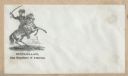
| Date: | 1860 |
|---|---|
| Description: | Union General George McClellan seated on a rearing horse. His saber is drawn and held over his head. A military camp appears in the background. Black ink o... |
| Date: | 1860 |
|---|---|
| Description: | An old woman, stooped over and holding a cane, has Union soldiers ("NORTH" on the left) and Confederate soldiers ("SOUTH" on the right) climbing ladders to... |
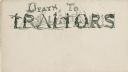
| Date: | 1860 |
|---|---|
| Description: | The letters to the words "DEATH TO TRAITORS" are made up of soldiers, Confederate flags, gallows, a hanged man and guns. A military camp is visible in the ... |
| Date: | 1860 |
|---|---|
| Description: | Envelope depicts a Zouave camp with five soldiers relaxing around a campfire in front of a tent. A tree branch and a drum are in the foreground. The captio... |
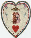
| Date: | 1920 |
|---|---|
| Description: | Valentine created using a "Whitney's Valentine Material" kit. The "folder" (card) has a boy in military uniform holding a rifle. He is kissing a girl on th... |
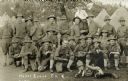
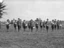
| Date: | 07 1915 |
|---|---|
| Description: | Group of soldiers of Co. K, 127th Infantry, 32nd Division, Wisconsin National Guard "at ease." Two men are eating, one holds a tin cup, two men hold mandol... |
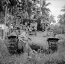
| Date: | 02 04 1944 |
|---|---|
| Description: | Tank crew at Saidor, New Guinea (present day Papua New Guinea). The soldier's names are, (standing) Sergeant William Preston of San Francisco, California, ... |
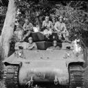
| Date: | 02 04 1944 |
|---|---|
| Description: | Tank crew at Saidor, New Guinea (present day Papua New Guinea). The soldier's names are, (top, left to right) Corporal Jim Malliares of Lowell, Massachuset... |

| Date: | 10 1776 |
|---|---|
| Description: | Broadside map showing the British invasion of New York city in August and September of 1776. The map shows important cities, forts, roads, hills, mountains... |

| Date: | 02 1777 |
|---|---|
| Description: | Map depicting the campaigns of October and November 1776, in Manhattan, Westchester, and part of New Jersey, published only a few months after the conclusi... |

| Date: | 03 1777 |
|---|---|
| Description: | Map showing the British and Hessian attack on Fort Washington in November of 1776. The movements and fortifications of the British and Hessian troops appea... |

| Date: | 04 1777 |
|---|---|
| Description: | Map showing the area from Newtown, Pennsylvania to Kingston, New Jersey, with routes and battles of British (red) and American forces (blue). The map inclu... |

| Date: | 1766 |
|---|---|
| Description: | Map of the region south of Lake Erie to the Ohio River. It shows forts, towns, Native American towns, mines, roads, mountains, swamps, lakes, and rivers. T... |
If you didn't find the material you searched for, our Library Reference Staff can help.
Call our reference desk at 608-264-6535 or email us at: