| Date: | |
|---|---|
| Description: | Photographic postcard of two images: the one on the left is titled: "A Sample Catch" and is of three men holding the fish they caught, with a dog sitting a... |

| Date: | 1878 |
|---|---|
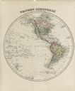
| Description: | This lithograph shows Greenland, North America, Central America, South America, Polynesia, Australia, the Pacific Ocean, the Atlantic Ocean, the Arctic Oce... |

| Date: | 1878 |
|---|---|
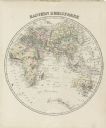
| Description: | This lithograph shows Africa, Europe, Asia, Australia, and the Antarctic Continent, the Atlantic Ocean, the Indian Ocean, the Arctic Ocean, the Pacific Oce... |

| Date: | |
|---|---|
| Description: | Elevated view overlooking a large lake. There appears to be a small island off the lakeshore. |

| Date: | 1900 |
|---|---|
| Description: | This photocopy map shows marshes, woods, buildings, and selected features including islands, mounds, old Fort Crawford, and "new site for a fort in questio... |

| Date: | 1942 |
|---|---|
| Description: | This photocopy plat map represents the relative position and size of the sloughs and islands in the Mississippi River, opposite Prairie du Chien. |

| Date: | |
|---|---|
| Description: | Illustration of Fort Armstrong on Rock Island, looking from opposite shoreline. There is a barge and other boats on the Mississippi River in front of the f... |

| Date: | 1786 |
|---|---|
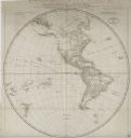
| Description: | This map is an updated version of d'Anville's 1761 map of the western hemisphere. He included more details to the north west coast of North America, partic... |

| Date: | 1786 |
|---|---|
| Description: | One half of a four sheet nautical chart, showing the coastlines of the north-west hemisphere. The interior lands are left bare, even of basic features such... |

| Date: | 1776 |
|---|---|
| Description: | This was one of the first maps available for the general British populace featuring America during the Revolutionary War. It includes forts, cities, topogr... |

| Date: | 1782 |
|---|---|
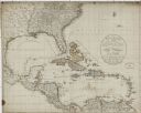
| Description: | Map of the West Indies and south eastern North America, remarkably detailed, showing cities, mountains, rivers, lakes, mines, plantations, forts, banks, an... |

| Date: | 1783 |
|---|---|
| Description: | This map is hand-colored and shows the boundaries of British, Spanish, and the newly recognized American claims, as well as the fishing rights granted to F... |

| Date: | 1788 |
|---|---|
| Description: | This map shows the north western coast of North America, including the southern coast of what will be Alaska and parts of the Aleutian Islands. It includes... |

| Date: | 1851 |
|---|---|
| Description: | Pictograph E., Plate 63, "Kaizheosh, and his Band from Lake Vieu Desert. Michigan and Wisconsin." A group of symbols including birds, animals, a fish and a... |

| Date: | 1780 |
|---|---|
| Description: | This map shows the townships, parishes, cities, towns, plantations, lakes, rivers, swamps, and roads near the coast of South Carolina and Georgia. Emphasis... |

| Date: | 1871 |
|---|---|
| Description: | A map of California showing railroad lines and reservations. |

| Date: | 1769 |
|---|---|
| Description: | Double hemispherical map showing the continents, islands, countries, and a few major cities of the world. The routes of a few explorers are depicted and la... |

| Date: | 1627 |
|---|---|
| Description: | Map of North and South America showing settlements, rivers, lakes, mountains, islands and regions of the western hemisphere. It includes an inset map of Gr... |

| Date: | 1630 |
|---|---|
| Description: | One of the few maps by Dutch cartographer Willem Blaeu depicting the Americas, this map shows regions, settlements, islands, mountains, forests, rivers, an... |

| Date: | 1675 |
|---|---|
| Description: | This atlas shows the western hemisphere, with a small portion of Spain and Africa. Several place names are labeled, such as the Plymouth colony, settlement... |
If you didn't find the material you searched for, our Library Reference Staff can help.
Call our reference desk at 608-264-6535 or email us at: