 Filter: Categories of Wisconsin Historical Images
Filter: Subject of Great Lakes
Filter: Subject of land
Filter: Categories of Wisconsin Historical Images
Filter: Subject of Great Lakes
Filter: Subject of land

| Date: | 07 01 1876 |
|---|---|
| Description: | This map shows towns, railroads, and rivers in Ohio, Michigan, Pennsylvania, New York, and Ontario that surround Lake Erie. A key to completed and uncomple... |

| Date: | 1905 |
|---|---|
| Description: | This map shows railroads, towns, lights, lights to be established, fog signals, light-vessels, lighted buoys, light-house depots, and light-house reservati... |

| Date: | 1846 |
|---|---|
| Description: | This map shows rivers, lakes, and towns in states west of the Mississippi River. Lake Michigan, Lake Superior, and Green Bay are labeled. Some areas are ou... |

| Date: | 2003 |
|---|---|
| Description: | The front of map shows trails throughout the bottom half of Wisconsin and includes text on snowmobile rules and tourism contacts. The reverse shows trails ... |

| Date: | 1975 |
|---|---|
| Description: | This map provides an index of outdated quadrangle maps for the state. Communities, counties, rivers, and lakes are labeled including Lake Michigan and Lake... |

| Date: | 1851 |
|---|---|
| Description: | This map shows townships, villages, Indian villages, railroads, roads, mills, prairies, swamps, and canals. An inset map shows a plat of the copper distric... |

| Date: | 1872 |
|---|---|
| Description: | This map includes depth shown by soundings and isolines and relief shown by contours. Tree species and locations are labeled, as well as a cranberry meadow... |

| Date: | 1696 |
|---|---|
| Description: | This sea chart and topographical map depicts the north east coast of Canada and North America, focusing on the Hudson Bay and Great Lakes regions. It shows... |

| Date: | 1685 |
|---|---|
| Description: | A detailed map of the western hemisphere showing cities, settlements, Native American land, rivers, lakes, mountains, the Great Lakes, and California as an... |

| Date: | 1709 |
|---|---|
| Description: | Map of North America, showing a few of the largest settlements, regions, islands, and a few rivers. The Great Lakes are depicted, but over-sized, and Calif... |

| Date: | 1766 |
|---|---|
| Description: | Map of the north western hemisphere using sinusoidal projection to show the curvature of the earth. It labels regions, cities, Native American land, island... |

| Date: | 1780 |
|---|---|
| Description: | Map of North America from Lake Ontario through the Great Plains, and James Bay to Illinois. It shows rivers, lakes, and mountains in great detail, and labe... |

| Date: | 11 24 1781 |
|---|---|
| Description: | Map showing New York, New England, and south eastern Canada. Boundaries, ports, and a few cities are shown, but the map focuses on regions, Native American... |

| Date: | 1745 |
|---|---|
| Description: | Landmark map of the Great Lakes region and one of the most advanced depictions of the lakes and surrounding areas for its time. It is the first map to intr... |

| Date: | 1783 |
|---|---|
| Description: | Map of eastern Canada and part of America, with an inset map of the Great Lakes region in the lower left corner. It shows boundaries, cities, settlements, ... |

| Date: | 1799 |
|---|---|
| Description: | Map of North America from the Great Lakes region to Baffins Bay. It shows settlements, Native American land, cities, trading houses and forts, mountains, a... |

| Date: | 1755 |
|---|---|
| Description: | Map of colonial America, showing the lands north of South Carolina and west of the Mississippi River. An inset map of the Carolinas and Georgia sits in the... |

| Date: | 1720 |
|---|---|
| Description: | Detailed, ornate, and comprehensive map of America from the east coast to present day Texas. Numerous features appear throughout the map, including Native ... |

| Date: | 1755 |
|---|---|
| Description: | Map of the Great Lakes region during the French and Indian War. It shows in great detail the territories, borders and boundary lines, Native American tribe... |
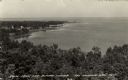
| Date: | |
|---|---|
| Description: | Elevated view of Green Bay from the Alpine Tower at Egg Harbor. A few dwellings are along the shoreline on the left. Caption reads: "View from the Alpine T... |
If you didn't find the material you searched for, our Library Reference Staff can help.
Call our reference desk at 608-264-6535 or email us at: