 Filter: Categories of Wisconsin Historical Images
Filter: Subject of Engraving
Filter: Subject of military art and science
Filter: Year of 1700-1799
Filter: Categories of Wisconsin Historical Images
Filter: Subject of Engraving
Filter: Subject of military art and science
Filter: Year of 1700-1799

| Date: | 1740 |
|---|---|
| Description: | Engraved and hand-colored map of the Iberian peninsula as a theater of war during the War of the Spanish Succession (1701-1714). The map is dedicated to Ki... |

| Date: | 1746 |
|---|---|
| Description: | A map of the western hemisphere, including parts of western Europe and Africa, showing the division of the Americas by the European powers. Weapons and fol... |

| Date: | 1776 |
|---|---|
| Description: | This was one of the first maps available for the general British populace featuring America during the Revolutionary War. It includes forts, cities, topogr... |

| Date: | 1783 |
|---|---|
| Description: | This map is hand-colored and shows the boundaries of British, Spanish, and the newly recognized American claims, as well as the fishing rights granted to F... |

| Date: | 1758 |
|---|---|
| Description: | This detailed map of north eastern America shows the boundaries, cities, mountains, rivers, lakes, Native American land and towns, and roads from east of t... |

| Date: | 1777 |
|---|---|
| Description: | Map showing the Hudson River in three sections, from New York City up through Lake Champlain, including cities, forts, roads, topographical features, and n... |

| Date: | 1719 |
|---|---|
| Description: | Map of the Great Lakes and the St. Lawrence river showing French and English cities and villages, trading posts, Indian villages and tribes, portages, for... |

| Date: | 1733 |
|---|---|
| Description: | This map of North America shows settlements, rivers, lakes, Native American land, trade winds, and numerous topographical features such as forests and moun... |

| Date: | 1755 |
|---|---|
| Description: | Large format map of America and Canada east of the Mississippi River. D'Anville marks the locations of rivers, lakes, settlements, cities, Native American ... |

| Date: | 1758 |
|---|---|
| Description: | Map showing lakes, rivers, cities, Native American land, and the boundaries of French and English claims in America and Canada north of New York. A title c... |

| Date: | 1770 |
|---|---|
| Description: | Map of North America from the Great Lakes to the northern portion of South America. It shows cities, Native American land, mountains, swamps, lakes, rivers... |

| Date: | 1776 |
|---|---|
| Description: | Map of the American colonies and land east of the Mississippi River. Prominent cities, forts, Native American land, mountains, rivers and lakes are all sho... |

| Date: | 1780 |
|---|---|
| Description: | Map of North America from Lake Ontario through the Great Plains, and James Bay to Illinois. It shows rivers, lakes, and mountains in great detail, and labe... |

| Date: | 1780 |
|---|---|
| Description: | Map of North America east of Mexico showing colonial boundaries, forts, cities, Native American land, mountains, waterfalls, lakes, and rivers. Short notes... |

| Date: | 02 1783 |
|---|---|
| Description: | Map of the United States and one of the first to show the new boundaries created by the Preliminary Treaty signed on January 20, 1783. The former colonies ... |

| Date: | 1782 |
|---|---|
| Description: | Map of America east of the Mississippi River. It shows regions, state boundaries extending to the Mississippi River, cities, forts, Native American lands, ... |

| Date: | 1770 |
|---|---|
| Description: | Map of North America showing the boundaries between French, Spanish, and English claims after the French and Indian War. Kitchin includes numerous place na... |
| Date: | 1776 |
|---|---|
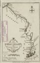
| Description: | Map of the Kenebec and Chaudiere River from the Atlantic Ocean to the Saint Lawrence River. Cities, forts, lakes, and tributaries along the two rivers are ... |

| Date: | 1767 |
|---|---|
| Description: | Map of the north east coast of America, showing colonial borders, cities, Native American land, lakes, rivers, and a few hills and mountains. Illustrated t... |

| Date: | 1755 |
|---|---|
| Description: | Map of colonial America, showing the lands north of South Carolina and west of the Mississippi River. An inset map of the Carolinas and Georgia sits in the... |
If you didn't find the material you searched for, our Library Reference Staff can help.
Call our reference desk at 608-264-6535 or email us at: