 Filter: Categories of Wisconsin Historical Images
Filter: Subject of Engraving
Filter: Subject of agriculture
Filter: Subject of botany
Filter: Categories of Wisconsin Historical Images
Filter: Subject of Engraving
Filter: Subject of agriculture
Filter: Subject of botany
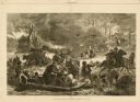
| Date: | 11 25 1871 |
|---|---|
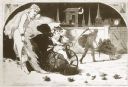
| Description: | Engraved view of Peshtigo Fire showing people trying to escape the flames by boat and on horseback. A team of cattle also seek refuge and several birds tak... |
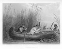
| Date: | 1884 |
|---|---|
| Description: | Three women in a canoe harvest wild rice. |

| Date: | 1884 |
|---|---|
| Description: | Cover of an advertising catalog for J.F. Seiberling, manufacturer of agricultural equipment, featuring an engraving of boys marching under a benner of "Vic... |

| Date: | 1655 |
|---|---|
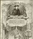
| Description: | Frontispiece to Newe Welt vnd americanische Historien (1655). |
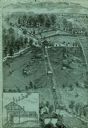
| Date: | |
|---|---|
| Description: | An engraving based on a drawing by Alexander Simplot. The image shows a very detailed aerial view of a hillside with a tramway traversing the side. There a... |
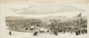
| Date: | 10 24 1863 |
|---|---|
| Description: | Panoramic wood-engraving of a cattle fair in New Haven, after a sketch by H.C. Curtis. Caption reads: "Cattle Show and Agricultural Faib [sic] at Ha... |

| Date: | 1835 |
|---|---|
| Description: | Two-story home with sloping roof. One man is whipping a team of eight cattle while another man drives the plow behind them. To the left stands a man near a... |
| Date: | |
|---|---|
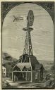
| Description: | Engraving of a farm with an Eclipse windmill. There is a cutaway view of the building beneath showing a man inside working at a saw. Another man is working... |

| Date: | |
|---|---|
| Description: | Letterhead of the Wisconsin Dairymen's Association, based in Fort Atkinson, Wisconsin, with names of officers and members of the Executive Board and an ima... |
| Date: | 01 1869 |
|---|---|
| Description: | Engraving after a drawing by Winslow Homer showing a crowned Baby New Year riding a velocipede through a hoop held by a woman, as the Grim Reaper, on the r... |
| Date: | |
|---|---|
| Description: | Illustration from an unknown book. At the top is a portrait of beekeeper Anton Jansha (1734-1773) and German text in a cartouche below his name. The bottom... |

| Date: | |
|---|---|
| Description: | Wisconsin State Bee Keepers Association membership certificate, signed by N.E. France Association President. No. 148. Illustrations of clover flowers and b... |
| Date: | 1570 |
|---|---|
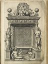
| Description: | Frontispiece for Abraham Ortelius' Theatrum Orbis Terrarum, published in 1570, and considered the first modern atlas. Title is surrounded by four figures r... |

| Date: | |
|---|---|
| Description: | Engraved print of a man riding atop a wagonload of hay pulled by a horse along a road in a hilly rural area. On the left is a barn and silos. |
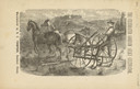
| Date: | 1880 |
|---|---|
| Description: | Front page of booklet with an engraving of a man with a team of two horses in a field with the "Celebrated Gorham Sulky Cultivator." |

| Date: | 1780 |
|---|---|
| Description: | This map shows the townships, parishes, cities, towns, plantations, lakes, rivers, swamps, and roads near the coast of South Carolina and Georgia. Emphasis... |

| Date: | 03 1777 |
|---|---|
| Description: | Map showing the British and Hessian attack on Fort Washington in November of 1776. The movements and fortifications of the British and Hessian troops appea... |

| Date: | 1671 |
|---|---|
| Description: | Map of Virginia depicting the discoveries detailed by John Smith in his exploration of the region. It shows Jamestown, Native American tribes and villages,... |

| Date: | 1676 |
|---|---|
| Description: | Map of Virginia and Maryland, based on John Smith's 1612 map and Augustine Herman's 1673 seminal map. It shows borders, counties, Native American land, tri... |

| Date: | 1760 |
|---|---|
| Description: | Map showing the towns, mountains, valleys, corn fields, and rivers of a portion of the Cherokee Nation. A few annotations on the map explain the land and r... |
If you didn't find the material you searched for, our Library Reference Staff can help.
Call our reference desk at 608-264-6535 or email us at: