 Filter: Categories of Wisconsin Historical Images
Filter: Subject of Bays
Filter: Subject of transportation
Filter: Categories of Wisconsin Historical Images
Filter: Subject of Bays
Filter: Subject of transportation

| Date: | 1776 |
|---|---|
| Description: | Map of Virginia and parts of Maryland and Delaware (written "De La War"). It shows borders, counties, cities, towns, plantations (marked by landowners name... |

| Date: | 1762 |
|---|---|
| Description: | Map of Virginia and parts of Maryland. It shows borders, boundary lines, Native American tribes and land, towns, forts, roads, mountains, waterfalls, bays,... |

| Date: | 1781 |
|---|---|
| Description: | Map of the southern portion of the Chesapeake Bay and surrounding lands. It shows counties, a few cities and towns, forts, roads, islands, topographical fe... |

| Date: | 1781 |
|---|---|
| Description: | Map of the Southeastern part of the British Colonies in North America, Gulf Coast and Caribbean. It illustrates the of the Spanish and English fleets, part... |

| Date: | 1759 |
|---|---|
| Description: | Map of New Orleans at the start of the French & Indian War, including two inset maps entitled "The Course of the Mississipi River from Bayagoulas to the Se... |

| Date: | 1769 |
|---|---|
| Description: | Map of New Orleans at the start of the French & Indian War, including two inset maps of the Mississippi River Delta and Fort la Balise. It shows streets, r... |
| Date: | |
|---|---|
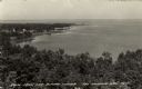
| Description: | Elevated view of Green Bay from the Alpine Tower at Egg Harbor. A few dwellings are along the shoreline on the left. Caption reads: "View from the Alpine T... |
| Date: | 1932 |
|---|---|
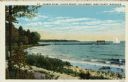
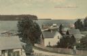
| Description: | Colorized postcard of Green Bay from Egg Harbor. A long pier with a rowboat at the side and a sailboat at the end. Caption reads: "Harbor Scene - Alpine Re... |

| Date: | 1932 |
|---|---|
| Description: | This map shows automobile routes across Wisconsin and parts of Illinois, Michigan, Minnesota and Iowa. The Mississippi River, Lake Michigan, Lake Superior,... |

| Date: | 1933 |
|---|---|
| Description: | This road map shows automobile routes across Wisconsin as well as portions of Illinois, Minnesota, Iowa and Michigan. Lakes Michigan, Superior and Winnebag... |

| Date: | 1933 |
|---|---|
| Description: | This map contains automobile routes across Wisconsin and portions of Illinois, Iowa, Minnesota and Michigan as well. The state borders are clearly defined... |

| Date: | 1934 |
|---|---|
| Description: | This map provides automobile routes through Wisconsin along with portions of Illinois, Iowa, Minnesota and Michigan. Lake Superior, Lake Michigan, Green B... |

| Date: | 1934 |
|---|---|
| Description: | This road map contains automobile routes for the state of Wisconsin as well as portions of Minnesota, Illinois, Iowa and Michigan. Lake Michigan, Lake Sup... |
| Date: | |
|---|---|
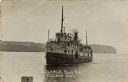
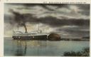
| Description: | View of the Steamer "Bon Ami" on Ellison Bay. A few people are on the deck. The tree-lined far shoreline is in the background. Caption reads: "Steamer Bon ... |
| Date: | 1915 |
|---|---|
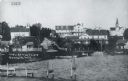
| Description: | View of Ephraim from the bay, with a pier in the foreground. Churches are on the left and right, and the Hillside Hotel is in the center near the shore. Ca... |
| Date: | |
|---|---|
| Description: | Elevated view from hill of the bay and Ephraim. A man is walking up the hill on a road with buildings and fences on both sides. Caption reads: "Greetings f... |

| Date: | |
|---|---|
| Description: | Elevated view of Green Bay from Ephraim. There is an island in the bay. Caption reads: "Lake View from Scandinavian Peasant Craft Shop, Ephraim, Wis." |

| Date: | |
|---|---|
| Description: | Elevated view of the bay side neighborhood, with a view of the bluffs across the bay. Caption reads: "View of Bay at Ephraim from Anderson's House." |

| Date: | |
|---|---|
| Description: | Drawing of a map showing the cruise routes from Eagle Inn Dock and the points of interest. There is a schedule and rates on the reverse. |
| Date: | |
|---|---|
| Description: | Twilight view of a steamer at the Ephraim dock. Caption reads: "Night Scene at the Boat Docks, Ephraim, Wis." |
If you didn't find the material you searched for, our Library Reference Staff can help.
Call our reference desk at 608-264-6535 or email us at: