 Filter: Categories of Wisconsin Historical Images
Filter: Subject of Bays
Filter: Subject of human settlements
Filter: Categories of Wisconsin Historical Images
Filter: Subject of Bays
Filter: Subject of human settlements

| Date: | 1913 |
|---|---|
| Description: | This map displays automobile routes across Wisconsin as well as Minnesota, Iowa, Michigan and Illinois. Cities, counties, Lake Michigan, Lake Superior, Gre... |

| Date: | 1710 |
|---|---|
| Description: | A seminal and fairly accurate map of the Great Lakes Region up to Baffin's Bay in Northern Canada. This is possibly the first printed map to locate Detroit... |

| Date: | 1746 |
|---|---|
| Description: | Map of North America from the southern portion of James Bay to Florida. It shows the colonies, cities, Native American land, and topological and geographic... |

| Date: | 1786 |
|---|---|
| Description: | One half of a four sheet nautical chart, showing the coastlines of the north-west hemisphere. The interior lands are left bare, even of basic features such... |

| Date: | 1791 |
|---|---|
| Description: | An English and updated version of d'Anville's 1746 map "Amérique Septentrionale Publiée sous les Auspices de Monseigneur le Duc d'Orleans Prémier Prince du... |

| Date: | 1696 |
|---|---|
| Description: | This sea chart and topographical map depicts the north east coast of Canada and North America, focusing on the Hudson Bay and Great Lakes regions. It shows... |

| Date: | 1698 |
|---|---|
| Description: | A sea chart of Hudson's Bay, Greenland, and the Canadian Arctic. This map shows rhumb lines extending from various points including two compass roses. Coas... |
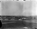
| Date: | |
|---|---|
| Description: | View from University Heights looking south across open fields towards barns and fences. (written on envelope: Camp Randall, Old Dane Country Fair Grounds).... |

| Date: | 1777 |
|---|---|
| Description: | This detailed map of the American colonies shows cities, villages, roads, mountains, lakes, rivers, swamps, counties, state boundaries, and Native American... |

| Date: | 1675 |
|---|---|
| Description: | This atlas shows the western hemisphere, with a small portion of Spain and Africa. Several place names are labeled, such as the Plymouth colony, settlement... |

| Date: | 1683 |
|---|---|
| Description: | Map of the north east coast of North America showing islands, regions, Native American land, bays, and a few European settlements. The Great Lakes appear i... |
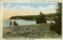
| Date: | |
|---|---|
| Description: | Colored postcard view near the extreme northern point of Door County. There is a man standing on the left in a field of flowers looking at the bay. Fishing... |
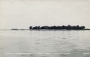
| Date: | |
|---|---|
| Description: | View across water towards Little Strawberry Island in Green Bay. The beach on the left side of the island is sandy, and a house can be seen among the trees... |

| Date: | 1752 |
|---|---|
| Description: | Map of the the coast line of Louisiana, focusing on the Mississippi, the Arkansas, the Red, the Osage, and the Missouri River. An inset map along the righ... |

| Date: | 1775 |
|---|---|
| Description: | Map of Boston and surrounding regions, from Massachusetts Bay to the Connecticut River, and including part of southern New Hampshire. It shows the colonies... |

| Date: | 1719 |
|---|---|
| Description: | Map of Maryland and surrounding states. It shows the boundaries, counties, cities, towns, rivers, and bays. Mountains, forests, and swamps appear pictoria... |

| Date: | 1778 |
|---|---|
| Description: | Detailed map of the Chesapeake Bay region and surrounding states. It shows a detailed account of the borders, cities, towns, islands, swamps, mountains, ri... |

| Date: | 10 1776 |
|---|---|
| Description: | Broadside map showing the British invasion of New York city in August and September of 1776. The map shows important cities, forts, roads, hills, mountains... |

| Date: | 11 1781 |
|---|---|
| Description: | Map of New York, Staten Island, and Long Island, showing the placements of forts, and the movement of troops in 1776. The map also includes towns, cities, ... |

| Date: | 1795 |
|---|---|
| Description: | Map of New Jersey showing counties, cities, towns, mills, landowners, roads, mountains, bays, rivers, and lakes. A few annotations dot the map, describing... |
If you didn't find the material you searched for, our Library Reference Staff can help.
Call our reference desk at 608-264-6535 or email us at: