 Filter: Categories of Wisconsin Historical Images
Filter: FORMAT_TYPE of prints, fine-art
Filter: Subject of persons
Filter: Subject of military art and science
Filter: Categories of Wisconsin Historical Images
Filter: FORMAT_TYPE of prints, fine-art
Filter: Subject of persons
Filter: Subject of military art and science
| Date: | 1860 |
|---|---|
| Description: | Jefferson Davis, seated on the floor, is blowing bubbles and General Winfield Scott, standing, is bursting them with his sword. The soap dish on a table in... |
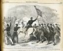
| Date: | 07 27 1861 |
|---|---|
| Description: | The caption with the image states, "Battle of Hoke's Run-Col. Starkweather with his Wisconsin Regiment deploying as skirmishers." The Battle of Hoke's Run ... |
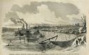
| Date: | 05 31 1862 |
|---|---|
| Description: | Engraved view of the Commisary [sic] depot of Major-General Halleck's army at Hamburg Landing. |
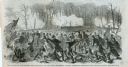
| Date: | 03 15 1862 |
|---|---|
| Description: | Engraved Illustration for the story titled: "The Fight at Fort Donelson". The illustration shows the Second Iowa Volunteers regiment attacking Confederate ... |
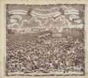
| Date: | 1819 |
|---|---|
| Description: | A commemorative handkerchief created by a wood engraving on white cotton fabric. The scene is the Manchester Reform Meeting, in England. A crowd of demonst... |
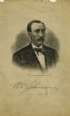
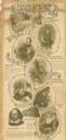
| Date: | |
|---|---|
| Description: | Head and shoulders steel engraved portrait of Ole C. Johnson, a colonel in the 15th Wisconsin Infantry. The following information was obtained from the Reg... |
| Date: | 10 13 1864 |
|---|---|
| Description: | Colorfully decorated letter received in the office of Wisconsin Governor James Lewis from Isaac Joiner of the Veterans Reserve Corps stationed in Alexandri... |
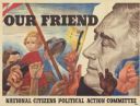
| Date: | 1944 |
|---|---|
| Description: | A poster featuring the face of President Franklin Roosevelt on the right, and several people on the left. A soldier is holding a child in his arms, and oth... |

| Date: | 1740 |
|---|---|
| Description: | Engraved and hand-colored map of the Iberian peninsula as a theater of war during the War of the Spanish Succession (1701-1714). The map is dedicated to Ki... |

| Date: | 05 1854 |
|---|---|
| Description: | This yellow and black wood block print broadside ties England and France's declaration of war against Russia during the Crimean War into a war against high... |
| Date: | 1900 |
|---|---|
| Description: | This advertisement features drawings of Shakespeare's Seven Ages beginning at the top left with: 'The Infant — "Perdita" Winter's Tale,' 'The Schoolboy — "... |

| Date: | 1929 |
|---|---|
| Description: | This map with north oriented to the upper left shows military forts, Indian villages, settler's houses with surnames, trading houses, lodges and encampment... |

| Date: | 1783 |
|---|---|
| Description: | This map is hand-colored and shows the boundaries of British, Spanish, and the newly recognized American claims, as well as the fishing rights granted to F... |

| Date: | 1719 |
|---|---|
| Description: | This extremely detailed and ornate map shows the cities, Native American land, mountains, lakes, rivers, and European claims of North America. An inset map... |

| Date: | 1733 |
|---|---|
| Description: | This map of North America shows settlements, rivers, lakes, Native American land, trade winds, and numerous topographical features such as forests and moun... |

| Date: | 1770 |
|---|---|
| Description: | Map of North America from the Great Lakes to the northern portion of South America. It shows cities, Native American land, mountains, swamps, lakes, rivers... |

| Date: | 1761 |
|---|---|
| Description: | Map covering southern Louisiana from Lake Ponchetrain to the Golf of Mexico and from Woods Bay in the west to the islands just east of Bay St. Louis. It sh... |

| Date: | 11 24 1861 |
|---|---|
| Description: | Letterhead of midshipman using a hammer for nailing the American flag to the mast, a symbol that they will not lower the flag in surrender. 4 page, folded,... |
| Date: | 10 10 1861 |
|---|---|
| Description: | Letterhead of a Revolutionary War soldier standing and holding up the American flag in his right hand, and holding a rifle in his left hand. A plow is behi... |

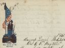
| Date: | 11 21 1861 |
|---|---|
| Description: | Letterhead of a Union General holding the American flag in his left hand and his sabre in his right. Text printed under the image reads: "Trust Our General... |
If you didn't find the material you searched for, our Library Reference Staff can help.
Call our reference desk at 608-264-6535 or email us at: