 Filter: Categories of Wisconsin Historical Images
Filter: FORMAT_TYPE of prints, fine-art
Filter: Subject of fishes
Filter: Categories of Wisconsin Historical Images
Filter: FORMAT_TYPE of prints, fine-art
Filter: Subject of fishes
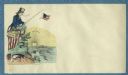
| Date: | 1860 |
|---|---|
| Description: | A man dressed in a blue jacket and light blue trousers fishes in a "SECESSION POND." He is sitting on the Union flag. His fishing line has a Union flag on ... |

| Date: | 1975 |
|---|---|
| Description: | This map provides an index of outdated quadrangle maps for the state. Communities, counties, rivers, and lakes are labeled including Lake Michigan and Lake... |
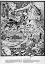
| Date: | 1987 |
|---|---|
| Description: | Imaginative pen-and-ink drawing titled, "Fish Tales (The Truth is Irrelevant, A Lie Well Told Lives Forever)." Sid adds the following words to describe the... |

| Date: | 1958 |
|---|---|
| Description: | This map shows state public hunting and/or fishing grounds, national forests, state forests, county forests.The lower margin includes an index to these loc... |
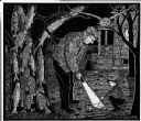
| Date: | 1967 |
|---|---|
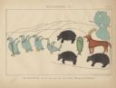
| Description: | Imaginative pen-and-ink drawing of John Anderson and Earle Robert (Rob) Metcalf hunting in the dark for nightcrawlers for fishing. John is standing and ill... |
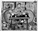
| Date: | 1973 |
|---|---|
| Description: | Imaginative pen-and-ink drawing of a man sitting at a table (inscribed PAM) and playing cards with a salmon and a muskelunge (muskie). The muskelunge appea... |
| Date: | 1974 |
|---|---|
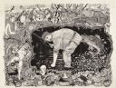
| Description: | Imaginative pen-and-ink drawing of a fisherman in waders, standing in ankle deep water and bending over with one hand in the water. He is looking towards h... |

| Date: | 1715 |
|---|---|
| Description: | One of Herman Moll's most famous maps, often referred to as The Codfish Map, it shows rivers and portages, cities, Indian villages, wind directions, routes... |

| Date: | 1746 |
|---|---|
| Description: | Map of North America from the southern portion of James Bay to Florida. It shows the colonies, cities, Native American land, and topological and geographic... |
| Date: | 1851 |
|---|---|
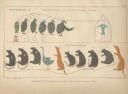
| Description: | Kenisteno, and his Band of Trout Lake, Wisconsin. One row of birds, animals and fish pictographs. |
| Date: | 1851 |
|---|---|
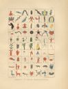
| Description: | Synopsis of Indian Hieroglyphics. Pictographs 71-140, including birds, human figures, plants, animals and other symbols. |
| Date: | 1851 |
|---|---|
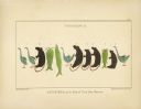
| Description: | Two pictographs: Pictograph C., Okundekund, and his Band of Ontonagon, Michigan, and Pictograph D., Kakake-Ogwunaosh, and his Band of the Head of the Wisc... |
| Date: | 1851 |
|---|---|
| Description: | Pictograph E., Plate 63, "Kaizheosh, and his Band from Lake Vieu Desert. Michigan and Wisconsin." A group of symbols including birds, animals, a fish and a... |

| Date: | 1780 |
|---|---|
| Description: | Map of North and South America, showing the boundaries of colonial territories, cities, settlements, rivers, lakes, and Native American land. Particular em... |

| Date: | 1760 |
|---|---|
| Description: | Map of North America based upon the cartographic work of de L'Isle. It shows cities, regions, lakes, rivers, Native American land, mountains, islands, and ... |
| Date: | 1856 |
|---|---|
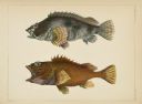
| Description: | A hand-colored lithograph, prepared from drawings by Bayard Taylor, depicts two highly colored fish, identified as Serranus tsirimenara, top, and |
| Date: | 1856 |
|---|---|
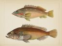
| Description: | A hand-colored lithograph, made from drawings by Hamilton Patterson, Perry Expedition draftsman, of two colorful fish. Both are identified as Sebastes |
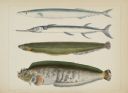
| Date: | 1856 |
|---|---|
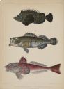
| Description: | A hand-colored lithograph of three fish specimens collected near Japan, from drawings prepared by H. Patterson. No. 1, top, is identified as Pelor japon... |
| Date: | 1856 |
|---|---|
| Description: | A hand-colored lithograph prepared from drawings by Perry expedition draftsman Hamilton Patterson of specimens collected in the waters of Japan. Included a... |
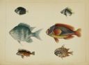
| Date: | 1856 |
|---|---|
| Description: | A hand-colored lithograph prepared from drawings made by draftsman Hamilton Patterson of four fish collected on Perry's expedition to Japan. They are numbe... |
If you didn't find the material you searched for, our Library Reference Staff can help.
Call our reference desk at 608-264-6535 or email us at: