 Filter: Categories of Wisconsin Historical Images
Filter: Year of 1700-1799
Filter: Year of 1780-1789
Filter: Categories of Wisconsin Historical Images
Filter: Year of 1700-1799
Filter: Year of 1780-1789
| Date: | 1780 |
|---|---|
| Description: | A letter written to William Preston. From Preston and Virginia Papers [Calendar series Volume 1]: "List of officers and number of men in their compa... |

| Date: | 06 22 1780 |
|---|---|
| Description: | A letter written by (illegible first name) Peterson to Michael Price in the 1700s. |

| Date: | 06 21 1780 |
|---|---|
| Description: | The address page of a letter written by Peterson to Michael Price. |

| Date: | 1780 |
|---|---|
| Description: | Map of Connecticut, Rhode Island, and Long Island. it shows the borders, cities, roads, islands, mountains, lakes and rivers. Navigational hazards along th... |

| Date: | 1780 |
|---|---|
| Description: | Map of eastern Massachusetts, Rhode Island, eastern Connecticut, and small portions of New Hampshire and Vermont. It shows the boundaries, counties, citie... |

| Date: | 1781 |
|---|---|
| Description: | Map of New Hampshire and surrounding regions. It shows borders, regions, cities, numerous forts, the country of the Iroquois, mountains, rivers, and lakes.... |
| Date: | 1783 |
|---|---|
| Description: | Map of the north east coast of the United States, north of Virginia and east of Lake Erie. It shows the states, forts, cities, towns, mountains, Niagara Fa... |

| Date: | 1782 |
|---|---|
| Description: | Map of America covering the Rio Grande to the Atlantic Ocean, showing boundaries, the colonies, cities, settlements, Native American lands and villages, m... |

| Date: | 1780 |
|---|---|
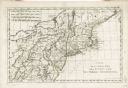
| Description: | Detailed map of America east of the Louisiana region. It shows forts, cities, borders and boundary lines, Native American land, the post road, mountains, w... |
| Date: | 1780 |
|---|---|
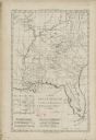
| Description: | Map of Florida and the south eastern States. The map shows cities, towns, forts, Native American land, mountains, rivers, and lakes. A small inset map of t... |

| Date: | 1784 |
|---|---|
| Description: | Detailed and ornate map of the newly formed United States. The borders of the southern states extend to the Mississippi River, though the states are only c... |

| Date: | 1783 |
|---|---|
| Description: | Map of the newly formed United States showing borders, regions, Native American land, cities, mountains, lakes, and rivers. It includes a small inset map o... |

| Date: | 1783 |
|---|---|
| Description: | Map of eastern Canada and part of America, with an inset map of the Great Lakes region in the lower left corner. It shows boundaries, cities, settlements, ... |

| Date: | 1782 |
|---|---|
| Description: | Map of America east of the Mississippi River. It shows regions, state boundaries extending to the Mississippi River, cities, forts, Native American lands, ... |

| Date: | 11 24 1781 |
|---|---|
| Description: | Map showing New York, New England, and south eastern Canada. Boundaries, ports, and a few cities are shown, but the map focuses on regions, Native American... |

| Date: | 02 1783 |
|---|---|
| Description: | Map of the United States and one of the first to show the new boundaries created by the Preliminary Treaty signed on January 20, 1783. The former colonies ... |

| Date: | 1780 |
|---|---|
| Description: | Map of North and South America, showing the boundaries of colonial territories, cities, settlements, rivers, lakes, and Native American land. Particular em... |

| Date: | 1780 |
|---|---|
| Description: | This map portrays North and South America at a very unusual angle, with north oriented towards the upper right corner. Colonies, Native American land, a fe... |

| Date: | 1780 |
|---|---|
| Description: | Map of North America east of Mexico showing colonial boundaries, forts, cities, Native American land, mountains, waterfalls, lakes, and rivers. Short notes... |

| Date: | 1780 |
|---|---|
| Description: | Map of North America from Lake Ontario through the Great Plains, and James Bay to Illinois. It shows rivers, lakes, and mountains in great detail, and labe... |
If you didn't find the material you searched for, our Library Reference Staff can help.
Call our reference desk at 608-264-6535 or email us at: