 Filter: Categories of Wisconsin Historical Images
Filter: Subject of War
Filter: Subject of water
Filter: Subject of land
Filter: Categories of Wisconsin Historical Images
Filter: Subject of War
Filter: Subject of water
Filter: Subject of land

| Date: | |
|---|---|
| Description: | Painting by Cal Peters depicting the battle of Bad Axe, also known as the Bad Axe massacre, at the Mississippi River on August 2, 1832. |

| Date: | 1852 |
|---|---|
| Description: | Illustration of the Ojibwa, the Sacs, and Foxes battling from canoes on the water. |

| Date: | 1855 |
|---|---|
| Description: | Map reads "Our Country" which is accompanied by a sailor with a flag to the left and workers rejoicing under the Constitution and Laws to the right. Across... |
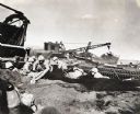
| Date: | 1945 |
|---|---|
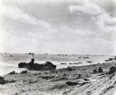
| Description: | Marines use an International TD-18 Diesel crawler tractor (TracTracTor) to pull an ammunition trailer from the mud. The original caption reads: "JAPANESE A... |
| Date: | 1945 |
|---|---|
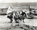
| Description: | Three marines dressed in uniform, carrying packs and holding guns, pull an ammunition cart through the water towards the beach at Iwo Jima. Military boats ... |
| Date: | 1945 |
|---|---|
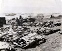
| Description: | Marines, killed in action, lie on stretchers covered with ponchos on the beach at Iwo Jima. Four marines attend to the dead. Tents, military boats, and an ... |
| Date: | 02 19 1945 |
|---|---|
| Description: | Marines on the beach and military boats, including an LSM 242, in the water at Iwo Jima. |
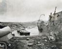
| Date: | 1945 |
|---|---|
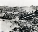
| Description: | Parts of destroyed boats and military equipment on the shoreline of Iwo Jima on D-Day. |
| Date: | 1945 |
|---|---|
| Description: | Marines dig foxholes into the sand on the beaches of Iwo Jima. The men are surrounded by military equipment, including a crane. An International Diesel cra... |

| Date: | 1958 |
|---|---|
| Description: | 26th of July Movement soldiers rest by a river in Oriente Province while on patrol during the Cuban Revolution. They are sitting on a rocky bank of the riv... |

| Date: | 06 1962 |
|---|---|
| Description: | Aerial view of old U.S. Army model H-21 helicopter, assigned to help Vietnamese forces fight the Viet Cong in the mountain region of Vietnam. The patchwork... |
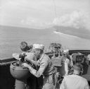
| Date: | 12 26 1943 |
|---|---|
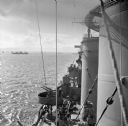
| Description: | Elevated view from aboard ship looking down on a soldier in a turret operating a range finder. These warships were participating in the heavy bombardment o... |
| Date: | 12 26 1943 |
|---|---|
| Description: | Navigation instruments on an American cruiser were checked by Lieutenant Commander Leonard Meyer of Appleton. Three other crew members are nearby. The crui... |
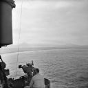
| Date: | 12 26 1943 |
|---|---|
| Description: | Elevated view looking down towards deck of an American cruiser leaving the base heading for the bombardment of Cape Gloucester, New Britain, New Guinea (pr... |
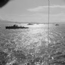
| Date: | 12 26 1943 |
|---|---|
| Description: | Elevated view, perhaps from an American Cruiser, of warships leaving the base heading for the bombardment of Cape Gloucester, New Britain, New Guinea (pres... |

| Date: | 12 26 1943 |
|---|---|
| Description: | Seaman 2nd Class Jerry Burg (left) of Milwaukee, Wisconsin, and Seaman 2nd Class Harold Dawson of Toledo, Ohio, man the plane spotting station on an Americ... |

| Date: | 1740 |
|---|---|
| Description: | Engraved and hand-colored map of the Iberian peninsula as a theater of war during the War of the Spanish Succession (1701-1714). The map is dedicated to Ki... |

| Date: | 05 01 1899 |
|---|---|
| Description: | Map showing the Schuylkill River with roads, ferries, and points of interest from Valley Forge to Philadelphia, Pennsylvania as it appeared during the Revo... |

| Date: | 1758 |
|---|---|
| Description: | This detailed map of north eastern America shows the boundaries, cities, mountains, rivers, lakes, Native American land and towns, and roads from east of t... |

| Date: | 1755 |
|---|---|
| Description: | Map of colonial America, showing the lands north of South Carolina and west of the Mississippi River. An inset map of the Carolinas and Georgia sits in the... |
If you didn't find the material you searched for, our Library Reference Staff can help.
Call our reference desk at 608-264-6535 or email us at: