 Filter: Categories of Wisconsin Historical Images
Filter: Subject of War
Filter: Subject of water
Filter: Subject of cities and towns
Filter: Categories of Wisconsin Historical Images
Filter: Subject of War
Filter: Subject of water
Filter: Subject of cities and towns

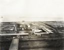
| Date: | 09 1918 |
|---|---|
| Description: | Elevated view of the U.S. Government War Exposition grounds at Grant Park. |

| Date: | 1855 |
|---|---|
| Description: | Map reads "Our Country" which is accompanied by a sailor with a flag to the left and workers rejoicing under the Constitution and Laws to the right. Across... |
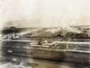
| Date: | 09 1918 |
|---|---|
| Description: | Elevated view of the U.S. Government War Exposition at Grant Park taken from a window the International Harvester building on Michigan Avenue. A large sign... |

| Date: | 09 1918 |
|---|---|
| Description: | Elevated view of the U.S. Government War Exposition at Grant Park taken from a window the International Harvester building on Michigan Avenue. A large crow... |
| Date: | 09 1918 |
|---|---|
| Description: | Elevated view of the U.S. Government War Exposition at Grant Park taken from a window the International Harvester building on Michigan Avenue. A large crow... |

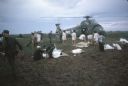
| Date: | 06 1962 |
|---|---|
| Description: | Helilift of corpses after a Viet Cong attack on the village of Vinh Quoi. The corpses are wrapped in sheets and lying atop mats on the ground in a field. S... |
| Date: | 06 1962 |
|---|---|
| Description: | In the aftermath of Viet Cong attack on the village of Vinh Quoi, corpses await helilift. The corpses are wrapped in sheets and lying atop woven mats in a ... |
| Date: | 1962 |
|---|---|
| Description: | Canal in Binh Hung Vietnam with numerous small boats and a crowd of people walking alongside. In the background is a large cross and a number of large that... |

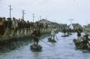
| Date: | 11 1961 |
|---|---|
| Description: | Sea Swallows, an anti-communist Vietnamese militia, begin an operation by boats on a canal in the vicinity of Van Dinh, Vietnam. Militia members hold guns ... |

| Date: | 06 1962 |
|---|---|
| Description: | Aerial view of old U.S. Army model H-21 helicopter, assigned to help Vietnamese forces fight the Viet Cong in the mountain region of Vietnam. The patchwork... |

| Date: | 1944 |
|---|---|
| Description: | Continental Transportation Lines, Inc. operating an International semi-truck (tractor-trailer) on a road with a hazy view of a bridge, a body of water and ... |

| Date: | 1918 |
|---|---|
| Description: | United States government bonds poster in the Fourth Liberty Loan "B" series. "Buy Liberty Bonds. Fourth Liberty Loan." Depicts enemy aircraft bombing New Y... |

| Date: | 05 01 1899 |
|---|---|
| Description: | Map showing the Schuylkill River with roads, ferries, and points of interest from Valley Forge to Philadelphia, Pennsylvania as it appeared during the Revo... |

| Date: | 1950 |
|---|---|
| Description: | This map shows regions in Northern Illinois and Southern Wisconsin roughly bounded by Lake Winnebago, the Kankakee River, Peoria, and Prairie du Chien. The... |

| Date: | 1758 |
|---|---|
| Description: | This detailed map of north eastern America shows the boundaries, cities, mountains, rivers, lakes, Native American land and towns, and roads from east of t... |

| Date: | 1758 |
|---|---|
| Description: | Map showing lakes, rivers, cities, Native American land, and the boundaries of French and English claims in America and Canada north of New York. A title c... |

| Date: | 1755 |
|---|---|
| Description: | Map of colonial America, showing the lands north of South Carolina and west of the Mississippi River. An inset map of the Carolinas and Georgia sits in the... |

| Date: | 1777 |
|---|---|
| Description: | Map of Colonial America east of Lake Michigan showing regions, cities, forts, Native American land, mountains, lakes, and rivers. Crossed swords and small ... |

| Date: | 1795 |
|---|---|
| Description: | Map of the United States east of the Mississippi River. It features roads, cities, towns, early settlements, Native American land, forts, mountains, rivers... |

| Date: | 1755 |
|---|---|
| Description: | Map of New England, with three inset maps of Fort Oswego, Fort du Quesne, and Fort Frederick. It shows colonies, a few cities, forts (marked as French or E... |
If you didn't find the material you searched for, our Library Reference Staff can help.
Call our reference desk at 608-264-6535 or email us at: