 Filter: Categories of Wisconsin Historical Images
Filter: Subject of War
Filter: Subject of water
Filter: Subject of battles
Filter: Categories of Wisconsin Historical Images
Filter: Subject of War
Filter: Subject of water
Filter: Subject of battles

| Date: | |
|---|---|
| Description: | Painting by Cal Peters depicting the battle of Bad Axe, also known as the Bad Axe massacre, at the Mississippi River on August 2, 1832. |

| Date: | 1852 |
|---|---|
| Description: | Illustration of the Ojibwa, the Sacs, and Foxes battling from canoes on the water. |
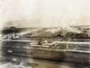
| Date: | 09 1918 |
|---|---|
| Description: | Elevated view of the U.S. Government War Exposition at Grant Park taken from a window the International Harvester building on Michigan Avenue. A large sign... |

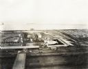
| Date: | 09 1918 |
|---|---|
| Description: | Elevated view of the U.S. Government War Exposition at Grant Park taken from a window the International Harvester building on Michigan Avenue. A large crow... |
| Date: | 09 1918 |
|---|---|
| Description: | Elevated view of the U.S. Government War Exposition at Grant Park taken from a window the International Harvester building on Michigan Avenue. A large crow... |
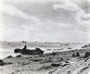
| Date: | 02 19 1945 |
|---|---|
| Description: | Marines on the beach and military boats, including an LSM 242, in the water at Iwo Jima. |
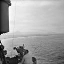
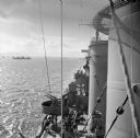
| Date: | 12 26 1943 |
|---|---|
| Description: | Elevated view from aboard ship looking down on a soldier in a turret operating a range finder. These warships were participating in the heavy bombardment o... |

| Date: | 12 26 1943 |
|---|---|
| Description: | Navigation instruments on an American cruiser were checked by Lieutenant Commander Leonard Meyer of Appleton. Three other crew members are nearby. The crui... |
| Date: | 12 26 1943 |
|---|---|
| Description: | Elevated view looking down towards deck of an American cruiser leaving the base heading for the bombardment of Cape Gloucester, New Britain, New Guinea (pr... |
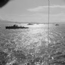
| Date: | 12 26 1943 |
|---|---|
| Description: | Elevated view, perhaps from an American Cruiser, of warships leaving the base heading for the bombardment of Cape Gloucester, New Britain, New Guinea (pres... |

| Date: | 12 26 1943 |
|---|---|
| Description: | Seaman 2nd Class Jerry Burg (left) of Milwaukee, Wisconsin, and Seaman 2nd Class Harold Dawson of Toledo, Ohio, man the plane spotting station on an Americ... |

| Date: | 1740 |
|---|---|
| Description: | Engraved and hand-colored map of the Iberian peninsula as a theater of war during the War of the Spanish Succession (1701-1714). The map is dedicated to Ki... |

| Date: | 1918 |
|---|---|
| Description: | United States government bonds poster in the Fourth Liberty Loan "B" series. "Buy Liberty Bonds. Fourth Liberty Loan." Depicts enemy aircraft bombing New Y... |

| Date: | 05 01 1899 |
|---|---|
| Description: | Map showing the Schuylkill River with roads, ferries, and points of interest from Valley Forge to Philadelphia, Pennsylvania as it appeared during the Revo... |

| Date: | 1777 |
|---|---|
| Description: | Map of Colonial America east of Lake Michigan showing regions, cities, forts, Native American land, mountains, lakes, and rivers. Crossed swords and small ... |

| Date: | 1795 |
|---|---|
| Description: | Map of the United States east of the Mississippi River. It features roads, cities, towns, early settlements, Native American land, forts, mountains, rivers... |

| Date: | 1755 |
|---|---|
| Description: | Map of New England, with three inset maps of Fort Oswego, Fort du Quesne, and Fort Frederick. It shows colonies, a few cities, forts (marked as French or E... |

| Date: | 1780 |
|---|---|
| Description: | Detailed topographical and political map of the area from Lake Champlain to Albany and the Hudson River. Relief is shown through hachures. The map shows ci... |

| Date: | 10 1776 |
|---|---|
| Description: | Broadside map showing the British invasion of New York city in August and September of 1776. The map shows important cities, forts, roads, hills, mountains... |

| Date: | 1781 |
|---|---|
| Description: | Map of the southern portion of the Chesapeake Bay and surrounding lands. It shows counties, a few cities and towns, forts, roads, islands, topographical fe... |
If you didn't find the material you searched for, our Library Reference Staff can help.
Call our reference desk at 608-264-6535 or email us at: