 Filter: Categories of Wisconsin Historical Images
Filter: Subject of War
Filter: Subject of rivers
Filter: Categories of Wisconsin Historical Images
Filter: Subject of War
Filter: Subject of rivers
| Date: | |
|---|---|
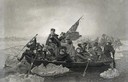
| Description: | Engraving of George Washington and his troops rowing across an icy Delaware River to attack the British, from the painting by E. Leutze. |

| Date: | 1855 |
|---|---|
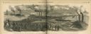
| Description: | Map reads "Our Country" which is accompanied by a sailor with a flag to the left and workers rejoicing under the Constitution and Laws to the right. Across... |
| Date: | 07 16 1864 |
|---|---|
| Description: | Illustration from Frank Leslie's Illustrated Newspaper depicting Admiral Porter's fleet passing through Colonel Bailey's dam during the War on Red R... |

| Date: | 1958 |
|---|---|
| Description: | 26th of July Movement soldiers resting by a stream in Oriente Province during the Cuban Revolution. Two soldiers aresleeping on the sandy bank and two sold... |

| Date: | 1958 |
|---|---|
| Description: | 26th of July Movement soldiers rest by a river in Oriente Province while on patrol during the Cuban Revolution. They are sitting on a rocky bank of the riv... |
| Date: | 06 1962 |
|---|---|
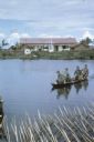
| Description: | U.S. Army advisor Major M.C. Curley and soldiers crossing a river in the delta region of Vietnam in a small boat to visit an outpost. A large building, a m... |

| Date: | 1962 |
|---|---|
| Description: | An American soldier inspects the papers of a Vietnamese man in the countryside along a river. Vietnamese soldiers and a boy are grouped around him. |

| Date: | 11 1961 |
|---|---|
| Description: | Sea Swallows, an anti-communist Vietnamese militia, begin an operation by boats on a canal in the vicinity of Van Dinh, Vietnam. Militia members hold guns ... |

| Date: | 06 1962 |
|---|---|
| Description: | Aerial view of old U.S. Army model H-21 helicopter, assigned to help Vietnamese forces fight the Viet Cong in the mountain region of Vietnam. The patchwork... |

| Date: | 05 1962 |
|---|---|
| Description: | Vietnamese Rangers escort a newly captured prisoner suspected of being Viet Cong down a gravel road in the vicinity of Bac Lien, Vietnam. The prisoner has ... |

| Date: | 1944 |
|---|---|
| Description: | Continental Transportation Lines, Inc. operating an International semi-truck (tractor-trailer) on a road with a hazy view of a bridge, a body of water and ... |

| Date: | 05 01 1899 |
|---|---|
| Description: | Map showing the Schuylkill River with roads, ferries, and points of interest from Valley Forge to Philadelphia, Pennsylvania as it appeared during the Revo... |

| Date: | 1950 |
|---|---|
| Description: | This map shows regions in Northern Illinois and Southern Wisconsin roughly bounded by Lake Winnebago, the Kankakee River, Peoria, and Prairie du Chien. The... |

| Date: | 1758 |
|---|---|
| Description: | This detailed map of north eastern America shows the boundaries, cities, mountains, rivers, lakes, Native American land and towns, and roads from east of t... |

| Date: | 1758 |
|---|---|
| Description: | Map showing lakes, rivers, cities, Native American land, and the boundaries of French and English claims in America and Canada north of New York. A title c... |

| Date: | 1755 |
|---|---|
| Description: | Map of colonial America, showing the lands north of South Carolina and west of the Mississippi River. An inset map of the Carolinas and Georgia sits in the... |

| Date: | 1777 |
|---|---|
| Description: | Map of Colonial America east of Lake Michigan showing regions, cities, forts, Native American land, mountains, lakes, and rivers. Crossed swords and small ... |

| Date: | 1795 |
|---|---|
| Description: | Map of the United States east of the Mississippi River. It features roads, cities, towns, early settlements, Native American land, forts, mountains, rivers... |

| Date: | 1755 |
|---|---|
| Description: | Map of New England, with three inset maps of Fort Oswego, Fort du Quesne, and Fort Frederick. It shows colonies, a few cities, forts (marked as French or E... |

| Date: | 1760 |
|---|---|
| Description: | Map showing upstate New York, Lake Ontario, and the St. Lawrence River during the last, decisive battle of the French and Indian War. The main map shows a ... |
If you didn't find the material you searched for, our Library Reference Staff can help.
Call our reference desk at 608-264-6535 or email us at: