 Filter: Categories of Wisconsin Historical Images
Filter: Subject of Superior, Lake
Filter: Subject of land
Filter: Subject of harbors
Filter: Categories of Wisconsin Historical Images
Filter: Subject of Superior, Lake
Filter: Subject of land
Filter: Subject of harbors

| Date: | 1886 |
|---|---|
| Description: | Bird's-eye view of Ashland, on the shores of Lake Superior, with insets of The Apostle Islands Chequamagon Bay & Ashland, and Distances from Ashland. |

| Date: | 1910 |
|---|---|
| Description: | Bird's-eye view looking east, with Washburn Harbor at center and Chequamegon Bay in Lake Superior covering most of the upper image. Streets with buildings... |

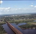
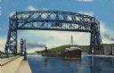
| Date: | 1913 |
|---|---|
| Description: | Aerial bridge and harbor, with a large boat passing underneath. A lamppost and a beacon are along the walkway towards the bridge on the left. Caption reads... |
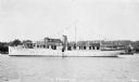
| Date: | 1933 |
|---|---|
| Description: | View across water of the motor yacht "The Nellewood" at dock at Madeline Island on Lake Superior. A group of passengers sit in the bow area. The "Nellewood... |

| Date: | 1880 |
|---|---|
| Description: | Map of Wisconsin including the eastern portions on Minnesota, Iowa, northern Illinois, and the western most portion of Michigan’s Upper Peninsula, showing ... |

| Date: | 1871 |
|---|---|
| Description: | Asaph Whittlesey arrived in Ashland in 1854, one of the earliest of the settlers who hoped the area would grow and make their fortunes. He drew this map of... |

| Date: | 1909 |
|---|---|
| Description: | This 1909 chart of the Apostle Islands, Chequamegon Bay, and the Lake Superior shoreline shows relief by contours and spot heights and depths by contours, ... |

| Date: | 1900 |
|---|---|
| Description: | This chart of the northern Apostle Islands and Lake Superior shoreline shows relief by contours and spot heights and depths by contours, gradient tints and... |

| Date: | 1871 |
|---|---|
| Description: | Asaph Whittlesey arrived in Ashland in 1854, one of the earliest of the settlers who hoped the area would grow and make their fortunes. He drew this map of... |

| Date: | 1925 |
|---|---|
| Description: | This map of Howard's Bay located at the Duluth Superior Harbor is a close view of Connors Point and shows a key to prevailing winds and water depth measure... |

| Date: | |
|---|---|
| Description: | Exterior of the menu for Paul's Cafe, with a bird's-eye view map of "Washburn's Natural Deep Water Land Locked Harbor," Chequamegon Bay, and the Apostle Is... |

| Date: | 1900 |
|---|---|
| Description: | This map shows streets, railroads, dock and harbor lines, and parks. The map includes population tables for 1880, 1890, 1900. |

| Date: | |
|---|---|
| Description: | Aerial view of harbor, with shipyards in the foreground and Superior in the background. Caption reads: "Aerial View of Harbor, Superior, Wisconsin." |

| Date: | 1989 |
|---|---|
| Description: | This color coded map shows the various rivers, lakes, bays, and islands that make up the harbor. It includes an index of industries (maritime and non-marit... |

| Date: | 1831 |
|---|---|
| Description: | This map shows the land that makes up Michigan, Wisconsin, Minnesota, Indiana, and parts of Canada. The Great Lakes are displayed prominently, along with s... |
| Date: | 08 1971 |
|---|---|
| Description: | Aerial view of an ore dock next to Hog Island. The town is in the distance. In the far background are the white storage buildings of the oil refinery. |
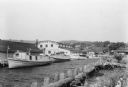
| Date: | 07 1936 |
|---|---|
| Description: | Fishing tugs are moored alongside the wharf at Bayfield. The large Bayfield Fish Co. building is identified in large letters on the end of the building. Th... |

| Date: | 03 23 1915 |
|---|---|
| Description: | Text on front reads: "Steamship William E. Corey, entering Duluth and Superior Harbor, Wis." A steamship entering the harbor under the Aerial Lift Bridge, ... |
| Date: | 1936 |
|---|---|
| Description: | Text on front reads: "Superior, Wisconsin." On reverse: "Harry Wm. Hosford. This view was taken from the Arrowhead Bridge. It just unloaded its cargo of co... |
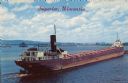
| Date: | 07 30 1952 |
|---|---|
| Description: | Text on reverse reads: "G-1–Ore Boat Leaving Duluth-Superior Harbor, Lift Bridge Raised. Giant lake freighters leave Duluth-Superior Harbor, the world's la... |
If you didn't find the material you searched for, our Library Reference Staff can help.
Call our reference desk at 608-264-6535 or email us at: