 Filter: Categories of Wisconsin Historical Images
Filter: Subject of Roads
Filter: Subject of military camps
Filter: Categories of Wisconsin Historical Images
Filter: Subject of Roads
Filter: Subject of military camps
| Date: | |
|---|---|
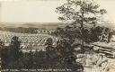
| Description: | Photographic postcard of an elevated view of a camp scene. Tents are pitched in rows with roads in between. Soldiers are walking along the roads. Two sold... |
| Date: | 01 22 1944 |
|---|---|
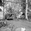
| Description: | Sergeant Walter Schaefer of Port Washington, Wisconsin, swings from a rope over an extremely muddy road just after a truck has just driven through at a mil... |
| Date: | 01 24 1944 |
|---|---|
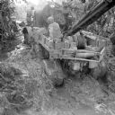
| Description: | "Beach Road," Robert Doyle's caption in the Milwaukee Journal said it best, "Saidor travel Bureau never reports roads impassable as long as wheels a... |
| Date: | 02 03 1944 |
|---|---|
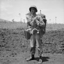
| Description: | Private First Class Carl Krejci of Chippewa Falls, Wisconsin, carries a heavy load as he leaves on patrol from camp in Saidor, New Guinea (present day Papu... |

| Date: | |
|---|---|
| Description: | A hand-drawn map of Camp Curtis which was prepared for Colonel R. McMurphy. |

| Date: | 1909 |
|---|---|
| Description: | This is one of a set of two topographical maps showing land use, roads, railroads, bridges, and buildings with ownership in parts of LaFayette, Greenfield,... |

| Date: | 1900 |
|---|---|
| Description: | This map shows portion of the military road from Fond du Lac to the Wisconsin River near Fort Winnebago, with mile markers and adjacent land use. A few pro... |

| Date: | 10 1776 |
|---|---|
| Description: | Broadside map showing the British invasion of New York city in August and September of 1776. The map shows important cities, forts, roads, hills, mountains... |

| Date: | 02 1777 |
|---|---|
| Description: | Map depicting the campaigns of October and November 1776, in Manhattan, Westchester, and part of New Jersey, published only a few months after the conclusi... |

| Date: | 03 1777 |
|---|---|
| Description: | Map showing the British and Hessian attack on Fort Washington in November of 1776. The movements and fortifications of the British and Hessian troops appea... |

| Date: | 04 1777 |
|---|---|
| Description: | Map showing the area from Newtown, Pennsylvania to Kingston, New Jersey, with routes and battles of British (red) and American forces (blue). The map inclu... |

| Date: | 1766 |
|---|---|
| Description: | Map of the region south of Lake Erie to the Ohio River. It shows forts, towns, Native American towns, mines, roads, mountains, swamps, lakes, and rivers. T... |

| Date: | 1909 |
|---|---|
| Description: | This the second of a set of two topographical maps showing land use, roads, railroads, bridges, and buildings with ownership in parts of LaFayette, Greenfi... |
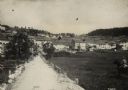
| Date: | |
|---|---|
| Description: | View of town of Lavarone in the southwest battlefront. |
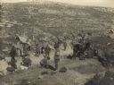
| Date: | |
|---|---|
| Description: | Caravan of Red Crescent soldiers traveling through the desert with supplies. |

| Date: | |
|---|---|
| Description: | Turkish soldiers breaking camp and packing up rucksacks in the mountains. |
If you didn't find the material you searched for, our Library Reference Staff can help.
Call our reference desk at 608-264-6535 or email us at:
