 Filter: Categories of Wisconsin Historical Images
Filter: Subject of Roads
Filter: Subject of military bases
Filter: Categories of Wisconsin Historical Images
Filter: Subject of Roads
Filter: Subject of military bases
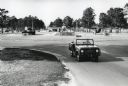
| Date: | 1964 |
|---|---|
| Description: | A man drives an International Harvester Scout past military vehicles on display near the entrance to Fort Stewart. |

| Date: | 1944 |
|---|---|
| Description: | A group of civilian workers from Port Hueneme exit an International trailer used in transportation to and from the naval base. The original caption reads: ... |

| Date: | 1944 |
|---|---|
| Description: | Two K-5 International trucks equipped with hoses and ladders used by the Camp Pendleton fire department are parked near a building and a road sign. The ori... |
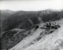
| Date: | 1944 |
|---|---|
| Description: | A man uses an International crawler tractor (TracTracTor) equipped with a bulldozer blade on a hillside in the construction of a road. The original caption... |
| Date: | |
|---|---|
| Description: | A road curves to the right and in the background is the Star Redoubt, a military structure built by Continental soldiers during the winter encampment of 17... |
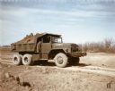
| Date: | 1952 |
|---|---|
| Description: | Color photograph of an engineer construction battalion with an M-51 dump truck. The battalion used the truck to transport topsoil along a dirt road at Fort... |
| Date: | 1967 |
|---|---|
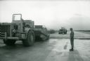
| Description: | A man stands beside an International 270 pay scraper at Phan Rang, an air base in South Vietnam. |
| Date: | 1967 |
|---|---|
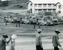
| Description: | Men from the Air Force's Red Horse squadron, a civil engineering support force, use International Harvester construction equipment to make way for a runway... |
| Date: | 02 05 1944 |
|---|---|
| Description: | View from road of the exterior of the Allied Officers' Club in Port Moresby, New Guinea (present day Papua New Guinea). It is built on posts above the wate... |
| Date: | |
|---|---|
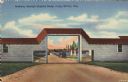
| Description: | Colorized postcard view of an arch at Camp McCoy with ramps on either side and a road passing through it. Parked cars and barracks are on the far side of t... |

| Date: | 11 1960 |
|---|---|
| Description: | View from side of road of a helicopter flying low over a hilly rural road with grass, wildflowers and trees at Guantanamo, Cuba. A chain link fence topped ... |

| Date: | 03 05 1965 |
|---|---|
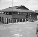
| Description: | View across road towards a one-story building with three cars parked in front near the corner of E. Washington Avenue and N. Stoughton Road. The building w... |
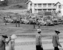
| Date: | 1967 |
|---|---|
| Description: | Men are walking in the foreground. In the background more men, in uniform, stand near several International Payscrapers parked in Phan Rang, Vietnam. Recen... |

| Date: | 1782 |
|---|---|
| Description: | Map of America east of the Mississippi River. It shows regions, state boundaries extending to the Mississippi River, cities, forts, Native American lands, ... |

| Date: | 1780 |
|---|---|
| Description: | Map of New York and parts of the neighboring states. It shows cities, forts, towns, roads, mountains, lakes, and rivers. several different boundary lines a... |

| Date: | 1780 |
|---|---|
| Description: | Detailed topographical and political map of the area from Lake Champlain to Albany and the Hudson River. Relief is shown through hachures. The map shows ci... |

| Date: | 1778 |
|---|---|
| Description: | Map of the land between Fort Ticonderoga and Albany. It shows cities, forts, mills, roads, mountains, swamps, waterfalls, lakes, and rivers. A few annotati... |

| Date: | 10 1776 |
|---|---|
| Description: | Broadside map showing the British invasion of New York city in August and September of 1776. The map shows important cities, forts, roads, hills, mountains... |

| Date: | 02 1777 |
|---|---|
| Description: | Map depicting the campaigns of October and November 1776, in Manhattan, Westchester, and part of New Jersey, published only a few months after the conclusi... |

| Date: | 03 1777 |
|---|---|
| Description: | Map showing the British and Hessian attack on Fort Washington in November of 1776. The movements and fortifications of the British and Hessian troops appea... |
If you didn't find the material you searched for, our Library Reference Staff can help.
Call our reference desk at 608-264-6535 or email us at: