 Filter: Categories of Wisconsin Historical Images
Filter: Subject of Ocean
Filter: Subject of transportation
Filter: Subject of lakes
Filter: Categories of Wisconsin Historical Images
Filter: Subject of Ocean
Filter: Subject of transportation
Filter: Subject of lakes

| Date: | 1798 |
|---|---|
| Description: | Uncolored. No scale. One of the earliest maps to show the proposed division of the northwest territory into states. |

| Date: | 1824 |
|---|---|
| Description: | Drawn and engraved by Sidney Hall. Published by Longman, Hurst, Rees, Orme, Brown & Green. Scale: 1:200. Partly colored. This is probably the second Europe... |

| Date: | |
|---|---|
| Description: | Map reads: "The United States from the Latest Authorities". View of the states and territories. |

| Date: | |
|---|---|
| Description: | Aerial view of a developed strip of land on Barnegat Bay showing the Atlantic ocean, houses, lakes, railroad tracks, a marina and a jetty in the distance. |

| Date: | 1942 |
|---|---|
| Description: | Holiday card showing Navy Pier in Chicago. There is snow on the ground, the lake is frozen and two lines of planes are flying overhead forming a "V" patter... |

| Date: | 1862 |
|---|---|
| Description: | This map of the southeastern United States shows cities and towns, rail lines, and geographic features such as rivers, mountains, lakes, and swamps. |
| Date: | |
|---|---|
| Description: | I had to know the point to which the path was tracked and when the definition would cease to be my own |

| Date: | |
|---|---|
| Description: | She didn't quite make clear what we were going to find when we got here on the outer edge of worry It wasn't Chinamen and it wasn't wild rice A ha... |

| Date: | 02 01 1793 |
|---|---|
| Description: | Text in the upper right corner reads, "A Map of The Western Part of the Territories belonging to the United States of America. Drawn from the best authorit... |
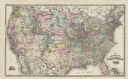
| Date: | 1878 |
|---|---|
| Description: | This map shows railroad lines, states, cities, rivers, and a small portion of Canada and Mexico. States appear in pink, yellow, and green. The Gulf of Mexi... |

| Date: | 1780 |
|---|---|
| Description: | This map shows the townships, parishes, cities, towns, plantations, lakes, rivers, swamps, and roads near the coast of South Carolina and Georgia. Emphasis... |

| Date: | 1871 |
|---|---|
| Description: | A map of California showing railroad lines and reservations. |

| Date: | 1630 |
|---|---|
| Description: | One of the few maps by Dutch cartographer Willem Blaeu depicting the Americas, this map shows regions, settlements, islands, mountains, forests, rivers, an... |

| Date: | 1679 |
|---|---|
| Description: | Decorative and detailed map of the eastern half of North America. Regions, cities, colonies, Native America land, rivers, lakes and some nautical features ... |

| Date: | 1700 |
|---|---|
| Description: | Map of the western hemisphere showing settelments, coastal features, islands, rivers, lakes, and pictoral representations of forests and mountains. The Gre... |

| Date: | 1636 |
|---|---|
| Description: | Map of North America, divided into regions, and showing some rivers, lakes, settlements, cities, mountains, and Native American land. Of the Great Lakes on... |

| Date: | 1684 |
|---|---|
| Description: | Map of North America showing some colonies, cities, rivers, lakes, and Native American land. Ship routes spread across both oceans, including one decorated... |

| Date: | 1719 |
|---|---|
| Description: | This extremely detailed and ornate map shows the cities, Native American land, mountains, lakes, rivers, and European claims of North America. An inset map... |

| Date: | 1729 |
|---|---|
| Description: | This small and hand-painted map focuses on the English claims in North America along the east coast from Cuba up to the southern tip of Greenland. It shows... |

| Date: | 1733 |
|---|---|
| Description: | This map of North America shows settlements, rivers, lakes, Native American land, trade winds, and numerous topographical features such as forests and moun... |
If you didn't find the material you searched for, our Library Reference Staff can help.
Call our reference desk at 608-264-6535 or email us at: