 Filter: Categories of Wisconsin Historical Images
Filter: Subject of Ocean
Filter: Subject of men
Filter: Subject of animals
Filter: Categories of Wisconsin Historical Images
Filter: Subject of Ocean
Filter: Subject of men
Filter: Subject of animals

| Date: | 1886 |
|---|---|
| Description: | Advertisement for the Atchison, Topeka and Santa Fe Railroad featuring an illustration of Uncle Sam stretched from the Missouri River to the Pacific Ocean.... |

| Date: | 1938 |
|---|---|
| Description: | A colorful pictorial map of Australia, featured on the front and back cover of a special Australian edition of International Trail. |

| Date: | 1915 |
|---|---|
| Description: | Boats unloading at Standard Oil Co.'s pier, with a horse, wagon, and a number of men handling lumber and other building materials. |
| Date: | |
|---|---|
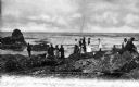
| Description: | A group of men, women, and children fishing from a rock outcrop along the pacific coast. Caption reads: "Fishing Rocks, Near Seaview, Wash." |

| Date: | |
|---|---|
| Description: | A fishermen smoking a pipe poses with fish strung from a wooden pole beneath an evergreen tree. |
| Date: | |
|---|---|
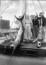
| Description: | Fishermen and women pose with a swordfish tied to a mast aboard a boat. |

| Date: | 1900 |
|---|---|
| Description: | View of a vacation party on a cliff stairway overlooking a seashore. Several men and women in formal dress walk down the stairway. Heavily retouched image. |

| Date: | 1625 |
|---|---|
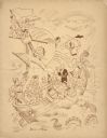
| Description: | An illustrated map of the world with captions in Latin. Illustrations include depictions of the seasons and the elements. |
| Date: | 02 02 1951 |
|---|---|
| Description: | Front cover of the menu and program for the Fifth Anniversary of the Secretary-Generalship of Trygve Lie, first Secretary-General of the United Nations (UN... |

| Date: | 1696 |
|---|---|
| Description: | Engraved and hand-colored map of Ethiopia, from Blaeu's General Atlas. Map title is framed by a man and a woman, both wearing head turbans, who are standin... |

| Date: | 1740 |
|---|---|
| Description: | Engraved and hand-colored map of the Iberian peninsula as a theater of war during the War of the Spanish Succession (1701-1714). The map is dedicated to Ki... |

| Date: | 07 21 1951 |
|---|---|
| Description: | Luncheon menu for the S.S. Argentina, with a map of Argentina with spot illustrations for the provinces and featured products or symbols, the coat o... |
| Date: | 1950 |
|---|---|
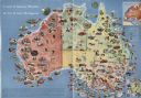
| Description: | Color illustrated map of Australia shows various resources available in the different regions of Australia. Original caption: "Australia is the the mi... |

| Date: | 1703 |
|---|---|
| Description: | Map of the Golf of Mexico and surrounding countries from the Great Lakes down to the northern most parts of South America. L'Isle labels cities, towns, and... |

| Date: | 1715 |
|---|---|
| Description: | One of Herman Moll's most famous maps, often referred to as The Codfish Map, it shows rivers and portages, cities, Indian villages, wind directions, routes... |

| Date: | 1746 |
|---|---|
| Description: | This world map from the German mathematician, historian, and geographer Johann Matthias Hase shows the major cities, islands, and the major political divis... |

| Date: | 1746 |
|---|---|
| Description: | Detailed map of the western hemisphere and part of Africa and Europe. Islands, cities, settlements, rivers, lakes, countries, and regions are marked. Mount... |

| Date: | 1759 |
|---|---|
| Description: | Map of North and South America showing regions, colonies, cities and settlements, rivers, lakes, and Native American land. Near the bottom left an inset ma... |

| Date: | 1636 |
|---|---|
| Description: | Map of North America, divided into regions, and showing some rivers, lakes, settlements, cities, mountains, and Native American land. Of the Great Lakes on... |

| Date: | 1719 |
|---|---|
| Description: | This extremely detailed and ornate map shows the cities, Native American land, mountains, lakes, rivers, and European claims of North America. An inset map... |
If you didn't find the material you searched for, our Library Reference Staff can help.
Call our reference desk at 608-264-6535 or email us at: