 Filter: Categories of Wisconsin Historical Images
Filter: Subject of Mines and mineral resources
Filter: Categories of Wisconsin Historical Images
Filter: Subject of Mines and mineral resources

| Date: | 1720 |
|---|---|
| Description: | Detailed, ornate, and comprehensive map of America from the east coast to present day Texas. Numerous features appear throughout the map, including Native ... |

| Date: | 1782 |
|---|---|
| Description: | Map of America covering the Rio Grande to the Atlantic Ocean, showing boundaries, the colonies, cities, settlements, Native American lands and villages, m... |

| Date: | 1792 |
|---|---|
| Description: | Map of the United States east of the Mississippi River and north of the Ohio River. It shows the borders between the north eastern states, Canada and the U... |

| Date: | 1794 |
|---|---|
| Description: | Extremely detailed map of the south-eastern states, south from Virginia and east of the Mississippi River. It shows roads and paths, cities, towns, forts, ... |

| Date: | 1795 |
|---|---|
| Description: | Heavily detailed and rare map of the United States. The map features the states, territories, cities, towns, forts, mines, mountains, swamps, lakes, and ri... |

| Date: | 1805 |
|---|---|
| Description: | Map of the United States. It shows the states, cities, towns, Native American land, mountains, lakes, and rivers. Tennessee, Kentucky, and Ohio are labeled... |

| Date: | 1800 |
|---|---|
| Description: | Map of the United States. It shows the states, including Tennessee, cities, towns, Native American land, mountains, lakes, and rivers. Lead mines appear ju... |

| Date: | 1781 |
|---|---|
| Description: | Map of the Southeastern part of the British Colonies in North America, Gulf Coast and Caribbean. It illustrates the of the Spanish and English fleets, part... |

| Date: | 1720 |
|---|---|
| Description: | Map showing the course of the Mississippi River from the Gulf of Mexico up past Lake Superior into Canada. It shows the towns, Native American tribes and l... |

| Date: | 1766 |
|---|---|
| Description: | Map of the region south of Lake Erie to the Ohio River. It shows forts, towns, Native American towns, mines, roads, mountains, swamps, lakes, and rivers. T... |

| Date: | 1895 |
|---|---|
| Description: | Outdoor group portrait of the miners who work at Optimal Mine. They are seated outdoors on the grass, and are wearing work clothes and hats. |
| Date: | 1993 |
|---|---|
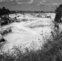
| Description: | Elevated view of trucks and conveyor belts working in the background of a limestone quarry. Grass and plants with small blossoms are in the foreground at t... |

| Date: | 1903 |
|---|---|
| Description: | Caption on negative sleeve reads, "Mining (?) town with view of saloon, restaurant and general store." A boardwalk runs along the fronts of the buildings. ... |

| Date: | 1910 |
|---|---|
| Description: | View across water towards the Lyle Mine and Ranier on the shoreline of Rainy Lake. |

| Date: | 1910 |
|---|---|
| Description: | A view across water towards the Rainy Lake shoreline, which includes Lyle Mine and Ranier. |
| Date: | |
|---|---|
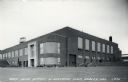
| Description: | View of the Cary Mine office building. Caption reads: "Cary Mine Office & Machine Shop, Hurley, Wis. |
| Date: | |
|---|---|
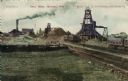
| Description: | View of the Cary iron Mine. Railroad tracks are in the right foreground. Caption reads: "Cary Mine, Hurley, Wis." |

| Date: | 1959 |
|---|---|
| Description: | Two views of Hurley. At the top is the Cary Mine. On the bottom is Silver Street lined with clubs and electric signs. Caption reads: "Greetings from Hurley... |

| Date: | 07 25 1927 |
|---|---|
| Description: | Men driving tractors pulling trailers, which are being loaded from a hopper at a granite quarry or mine. On the far right is a steam shovel. |

| Date: | 07 25 1927 |
|---|---|
| Description: | Men driving tractors pulling trailers, which are being loaded from a hopper at a granite quarry or mine. |
If you didn't find the material you searched for, our Library Reference Staff can help.
Call our reference desk at 608-264-6535 or email us at: