 Filter: Categories of Wisconsin Historical Images
Filter: Subject of Mines and mineral resources
Filter: Subject of military art and science
Filter: Categories of Wisconsin Historical Images
Filter: Subject of Mines and mineral resources
Filter: Subject of military art and science
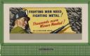
| Date: | 1944 |
|---|---|
| Description: | War Manpower Commission Design No. 7, "Metal Miner." The poster features a man in a cave with mining equipment. At center bottom of the poster the audience... |
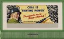
| Date: | 1944 |
|---|---|
| Description: | War Manpower Commission Design No. 7, "Coal Miner." The poster features a man in a cave with mining equipment. At center bottom of the poster the audience ... |

| Date: | 1847 |
|---|---|
| Description: | A hand-colored map that shows the area south and east of the Wisconsin and Fox Rivers, as well as a few landmarks just north of that area. The township gri... |
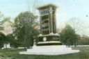
| Date: | 1910 |
|---|---|
| Description: | Hand-colored lantern slide of the Indiana Monument at the Andersonville National Cemetery. The monument was made of Montello granite at a cost of $10,000 i... |
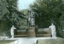
| Date: | 1910 |
|---|---|
| Description: | Hand-colored lantern slide of the Illinois Memorial at Andersonville National Cemetery. A bronze sculpture depicting Columbia, Youth and a Maiden is mounte... |

| Date: | 1783 |
|---|---|
| Description: | This map is hand-colored and shows the boundaries of British, Spanish, and the newly recognized American claims, as well as the fishing rights granted to F... |

| Date: | 1792 |
|---|---|
| Description: | Map of the United States east of the Mississippi River and north of the Ohio River. It shows the borders between the north eastern states, Canada and the U... |

| Date: | 1781 |
|---|---|
| Description: | Map of the Southeastern part of the British Colonies in North America, Gulf Coast and Caribbean. It illustrates the of the Spanish and English fleets, part... |

| Date: | 1720 |
|---|---|
| Description: | Map showing the course of the Mississippi River from the Gulf of Mexico up past Lake Superior into Canada. It shows the towns, Native American tribes and l... |

| Date: | 1766 |
|---|---|
| Description: | Map of the region south of Lake Erie to the Ohio River. It shows forts, towns, Native American towns, mines, roads, mountains, swamps, lakes, and rivers. T... |

| Date: | 1857 |
|---|---|
| Description: | Great Seal of the State of Wisconsin as found in American Farmer, vol. 9. |

| Date: | |
|---|---|
| Description: | 1881 version of the Coat of Arms of the State of Wisconsin. |
If you didn't find the material you searched for, our Library Reference Staff can help.
Call our reference desk at 608-264-6535 or email us at: