 Filter: Categories of Wisconsin Historical Images
Filter: Subject of Mines and mineral resources
Filter: Subject of land
Filter: Subject of michigan, lake
Filter: Categories of Wisconsin Historical Images
Filter: Subject of Mines and mineral resources
Filter: Subject of land
Filter: Subject of michigan, lake

| Date: | 1847 |
|---|---|
| Description: | A hand-colored map that shows the area south and east of the Wisconsin and Fox Rivers, as well as a few landmarks just north of that area. The township gri... |

| Date: | 1837 |
|---|---|
| Description: | This map shows the townships, roads, trails, natural land forms, vegetation, mill sites and lead and copper deposits in the Wisconsin Territory at the time... |

| Date: | 1846 |
|---|---|
| Description: | This map shows the counties and towns in existence at the time as well as lead and copper mines. |

| Date: | 1849 |
|---|---|
| Description: | Published a year after Wisconsin entered statehood, this map shows the counties and towns in existence at the time - mainly in southern/southeastern Wiscon... |

| Date: | 1850 |
|---|---|
| Description: | This detailed map outlines mid and southern WI county boundaries in bright color, and city/town lines are provided. Other marks include lead mines, copper ... |

| Date: | 1851 |
|---|---|
| Description: | Map outlines mid and southern Wisconsin county boundaries in blue, and city/town lines are provided. Other marks include mines, plank roads, and railroads. |

| Date: | 1853 |
|---|---|
| Description: | Southern two thirds of Wisconsin with county boundaries hand-colored in red. The map displays towns, railroads, plan roads and mines. The scale is ten mile... |

| Date: | 1853 |
|---|---|
| Description: | Railroad map outlines mid and southern Wisconsin county boundaries in red, and city/town lines are provided. Other marks include lead mines, copper mines, ... |

| Date: | 1854 |
|---|---|
| Description: | This map shows surveyed counties in blue, yellow, and pink, railroads, plank roads and mines. Lake Michigan, the Mississippi River, other rivers and lakes,... |

| Date: | 1855 |
|---|---|
| Description: | This map shows the township survey grid and identifies counties, named towns, rivers, lakes, railroads, plank roads, mines, and the Menomonee Reservation. ... |
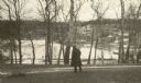
| Date: | 02 1925 |
|---|---|
| Description: | An unidentified man looks across Snail Shell Harbor at the remains of the Jackson Iron Company works. The large furnace complex is visible through the tree... |
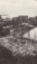
| Date: | 02 1925 |
|---|---|
| Description: | Elevated view of the abandoned Jackson Iron Company furnace complex at Fayette, on the shore of Snail Shell Harbor. Lake Michigan is in the background. |
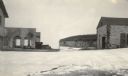
| Date: | 02 1925 |
|---|---|
| Description: | Dolomite cliffs along Snail Shell Harbor are seen in the background between the ruined buildings of the company store, left, and the machine shop on the gr... |

| Date: | 1871 |
|---|---|
| Description: | This map shows railroads, canals, towns and some lighthouses. Areas of the company lands proper, tin, iron, gold & silver, silver islet, and lead are color... |

| Date: | 1719 |
|---|---|
| Description: | Map of North America showing political boundaries, areas of Indian habitation, cities, towns, ports, rivers, mines, and other notable for North America fro... |

| Date: | 1745 |
|---|---|
| Description: | Landmark map of the Great Lakes region and one of the most advanced depictions of the lakes and surrounding areas for its time. It is the first map to intr... |

| Date: | 1720 |
|---|---|
| Description: | Map showing the course of the Mississippi River from the Gulf of Mexico up past Lake Superior into Canada. It shows the towns, Native American tribes and l... |
If you didn't find the material you searched for, our Library Reference Staff can help.
Call our reference desk at 608-264-6535 or email us at: