 Filter: Categories of Wisconsin Historical Images
Filter: Subject of Military camps
Filter: Categories of Wisconsin Historical Images
Filter: Subject of Military camps
| Date: | 02 10 1943 |
|---|---|
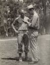
| Description: | Robert Doyle interviews Private Floyd Flayter, (shirtless) of Milwaukee, Wisconsin at a training ground somewhere in Australia. A firearm is laying on the ... |
| Date: | 10 24 1943 |
|---|---|
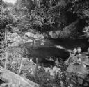
| Description: | Robert Doyle's caption for Image ID: 99742 says it best, "The ol' swimmin' hole, South Pacific style. Every afternoon it is filled with shouting soldiers i... |
| Date: | 10 24 1943 |
|---|---|
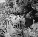
| Description: | Three officers of General Walter Krueger's staff stand on a log in front of a swimming hole located on Goodenough Island, in the Solomon Sea, New Guinea (p... |
| Date: | |
|---|---|
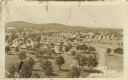
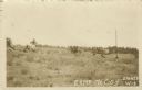
| Description: | Elevated view of Fort McCoy with rows of tents among trees. There is a row of automobiles parked in the center, and a row of barracks on the left. Caption ... |
| Date: | |
|---|---|
| Description: | View of troops and caissons on a hillside at Camp McCoy. Caption reads: "Camp McCory, Sparta, Wis." |

| Date: | |
|---|---|
| Description: | A hand-drawn map of Camp Curtis which was prepared for Colonel R. McMurphy. |

| Date: | 1909 |
|---|---|
| Description: | This is one of a set of two topographical maps showing land use, roads, railroads, bridges, and buildings with ownership in parts of LaFayette, Greenfield,... |
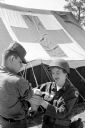
| Date: | 06 15 1961 |
|---|---|
| Description: | Pfc. Richard Sroda, a public information specialist with the 32nd Division, was the photographer and Sp4 David Gordon, public information specialist for th... |
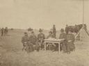
| Date: | 09 1887 |
|---|---|
| Description: | Outdoor group portrait of six men sitting around a table in military uniform in an open field. On the table are pens, an inkwell, two cigar boxes and paper... |

| Date: | 1900 |
|---|---|
| Description: | This map shows portion of the military road from Fond du Lac to the Wisconsin River near Fort Winnebago, with mile markers and adjacent land use. A few pro... |
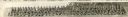
| Date: | 1917 |
|---|---|
| Description: | Panoramic group portrait of Company "K" Fourth Wisconsin Infantry. In the background is a rock formation, one of several in the area, with trees. The soldi... |
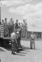
| Date: | 07 13 1945 |
|---|---|
| Description: | A work shift of German prisoners at a prisoner of war camp are being loaded onto a truck to be conveyed to work at a local cannery. |
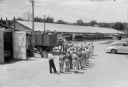
| Date: | 07 13 1945 |
|---|---|
| Description: | Elevated view of a work shift of German prisoners at a prisoner of war camp marching to a truck to be conveyed to work at a local cannery. |
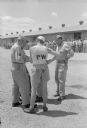
| Date: | 07 13 1945 |
|---|---|
| Description: | Two German prisoners and two American officers discussing some papers while standing outdoors. In the background, German prisoners of war are lined up for ... |

| Date: | 10 1776 |
|---|---|
| Description: | Broadside map showing the British invasion of New York city in August and September of 1776. The map shows important cities, forts, roads, hills, mountains... |

| Date: | 02 1777 |
|---|---|
| Description: | Map depicting the campaigns of October and November 1776, in Manhattan, Westchester, and part of New Jersey, published only a few months after the conclusi... |

| Date: | 03 1777 |
|---|---|
| Description: | Map showing the British and Hessian attack on Fort Washington in November of 1776. The movements and fortifications of the British and Hessian troops appea... |

| Date: | 04 1777 |
|---|---|
| Description: | Map showing the area from Newtown, Pennsylvania to Kingston, New Jersey, with routes and battles of British (red) and American forces (blue). The map inclu... |

| Date: | 1766 |
|---|---|
| Description: | Map of the region south of Lake Erie to the Ohio River. It shows forts, towns, Native American towns, mines, roads, mountains, swamps, lakes, and rivers. T... |
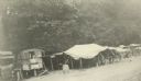
| Date: | 02 01 1919 |
|---|---|
| Description: | Mess hall and kitchen in a truck located in Vaux Varennes. Captioned: ""Salle a manger" and "Cuisine" at Vaux Varennes in the Aieux Country." |
If you didn't find the material you searched for, our Library Reference Staff can help.
Call our reference desk at 608-264-6535 or email us at: