 Filter: Categories of Wisconsin Historical Images
Filter: Subject of Military camps
Filter: Reproduction Rights of For Sale
Filter: Categories of Wisconsin Historical Images
Filter: Subject of Military camps
Filter: Reproduction Rights of For Sale

| Date: | 1900 |
|---|---|
| Description: | This map shows portion of the military road from Fond du Lac to the Wisconsin River near Fort Winnebago, with mile markers and adjacent land use. A few pro... |
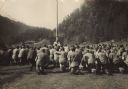
| Date: | 1917 |
|---|---|
| Description: | Panoramic group portrait of Company "K" Fourth Wisconsin Infantry. In the background is a rock formation, one of several in the area, with trees. The soldi... |
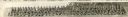
| Date: | 07 13 1945 |
|---|---|
| Description: | A work shift of German prisoners at a prisoner of war camp are being loaded onto a truck to be conveyed to work at a local cannery. |
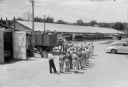
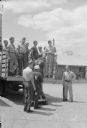
| Date: | 07 13 1945 |
|---|---|
| Description: | Elevated view of a work shift of German prisoners at a prisoner of war camp marching to a truck to be conveyed to work at a local cannery. |
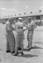
| Date: | 07 13 1945 |
|---|---|
| Description: | Two German prisoners and two American officers discussing some papers while standing outdoors. In the background, German prisoners of war are lined up for ... |

| Date: | 10 1776 |
|---|---|
| Description: | Broadside map showing the British invasion of New York city in August and September of 1776. The map shows important cities, forts, roads, hills, mountains... |

| Date: | 02 1777 |
|---|---|
| Description: | Map depicting the campaigns of October and November 1776, in Manhattan, Westchester, and part of New Jersey, published only a few months after the conclusi... |

| Date: | 03 1777 |
|---|---|
| Description: | Map showing the British and Hessian attack on Fort Washington in November of 1776. The movements and fortifications of the British and Hessian troops appea... |

| Date: | 04 1777 |
|---|---|
| Description: | Map showing the area from Newtown, Pennsylvania to Kingston, New Jersey, with routes and battles of British (red) and American forces (blue). The map inclu... |

| Date: | 1766 |
|---|---|
| Description: | Map of the region south of Lake Erie to the Ohio River. It shows forts, towns, Native American towns, mines, roads, mountains, swamps, lakes, and rivers. T... |
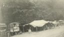
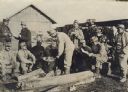
| Date: | 02 01 1919 |
|---|---|
| Description: | Mess hall and kitchen in a truck located in Vaux Varennes. Captioned: ""Salle a manger" and "Cuisine" at Vaux Varennes in the Aieux Country." |

| Date: | 1909 |
|---|---|
| Description: | This the second of a set of two topographical maps showing land use, roads, railroads, bridges, and buildings with ownership in parts of LaFayette, Greenfi... |

| Date: | |
|---|---|
| Description: | Elevated view of tents at Camp Douglas, with rock formations in the background. Man standing in foreground with hands in his back pockets is Edwin L. Lownd... |

| Date: | 1916 |
|---|---|
| Description: | Camp of the 1st Wisconsin Infantry at Leon Springs, Texas. Soldiers are standing near tents, with some men sitting astride horses. |
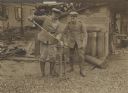
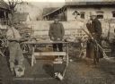
| Date: | |
|---|---|
| Description: | Two German soldiers using the services of a field carpentry detachment to sharpen a saber using a hand cranked sharpening wheel outdoors next to a shed. |
| Date: | 1914 |
|---|---|
| Description: | Sunday mass for Austrian soldiers, members of a "Tiroler Standschützen" unit, in South Tyrol during World War I. |
| Date: | 1914 |
|---|---|
| Description: | Two soldiers with a small forge during World War I. One of the men is smoking a pipe. There is a wagon in the background. |
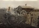
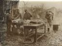
| Date: | 1914 |
|---|---|
| Description: | Soldiers are standing around while a cook is working at the outdoor field kitchen on the front during World War I. |
| Date: | 1914 |
|---|---|
| Description: | Austrian soldiers slaughtering on a Serbian farm during World War I. |
| Date: | 1914 |
|---|---|
| Description: | Soldiers relaxing and eating around a man cooking over an outdoor fire. |
If you didn't find the material you searched for, our Library Reference Staff can help.
Call our reference desk at 608-264-6535 or email us at: