 Filter: Categories of Wisconsin Historical Images
Filter: Subject of Land
Filter: County of Dane
Filter: Subject of human settlements
Filter: Categories of Wisconsin Historical Images
Filter: Subject of Land
Filter: County of Dane
Filter: Subject of human settlements
| Date: | |
|---|---|
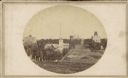
| Description: | A view looking south down Wisconsin Avenue toward the Capitol Square where portions of the second and third Wisconsin State Capitols are visible. This pers... |

| Date: | 1855 |
|---|---|
| Description: | Part of George Harrison's "Map of the City of Madison," showing the development of the isthmus and the small size of the second Capitol (54' x 104') in com... |

| Date: | 1896 |
|---|---|
| Description: | A portion of John B. Heim's map of the Water Works System of Madison showing the size of the third Wisconsin Capitol (228' x 226') in comparison with the C... |
| Date: | 1909 |
|---|---|
| Description: | A billboard displays events at the foot of Bascom Hill from the bottom east side on the University of Wisconsin-Madison campus. Bascom Hall with dome (form... |
| Date: | 1900 |
|---|---|
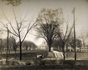
| Description: | The view of Bascom Hill and upper campus of the University of Wisconsin Madison seen from the roof of the Wisconsin Historical Society. |
| Date: | 1900 |
|---|---|
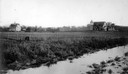
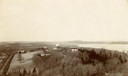
| Description: | Wetland, grassy pasture, ring fence are part of the College of Agriculture Farm on the University of Wisconsin Madison campus. |
| Date: | 1900 |
|---|---|
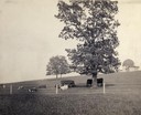
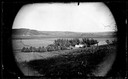
| Description: | Fenced-in, the cattle find a grassy pasture of Observatory Hill below Washburn Observatory on the University of Wisconsin-Madison campus. |
| Date: | 1899 |
|---|---|
| Description: | View of home atop of Observatory Hill on the University of Wisconsin-Madison campus. |
| Date: | 1926 |
|---|---|
| Description: | View of Adams, Tripp and Van Hise Halls. All are residence halls on the University of Wisconsin campus with Picnic Point and Lake Mendota in the backgroun... |

| Date: | 1945 |
|---|---|
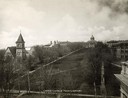
| Description: | View of the lower campus of the University of Wisconsin-Madison includes Bascom Hill, Wisconsin Historical Society, Memorial Union and the Armory (Red Gym ... |

| Date: | 1945 |
|---|---|
| Description: | Aerial view of Bascom Hill, Bascom Hall, Wisconsin Historical Society on the University of Wisconsin Madison campus with Lake Mendota on the right. |

| Date: | 1923 |
|---|---|
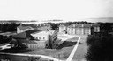
| Description: | Aerial view of the Wisconsin Historical Society, Science Hall, and Bascom Hall on Bascom Hill on the University of Wisconsin-Madison campus. Lake Mendota i... |
| Date: | 1963 |
|---|---|
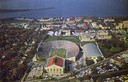
| Description: | Aerial view of Camp Randall during a football game on the University of Wisconsin-Madison campus with Picnic Point in the background. |
| Date: | 1900 |
|---|---|
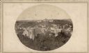
| Description: | Elevated view of Observatory Hill on the University of Wisconsin Madison campus of the United States National, Wisconsin State Farm Experiment Station, Pro... |

| Date: | 1929 |
|---|---|
| Description: | View of State Street towards Bascom Hill, with Schaeffer's Lavernette, a soda fountain, Student's Book Exchange, and the University Coop. |
| Date: | 1873 |
|---|---|
| Description: | View across field towards the Amund Rustebakke farm. Twelve haystacks dominate the left and center of the image, and two people are standing on top of the ... |
| Date: | 1880 |
|---|---|
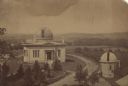
| Description: | Elevated view of the University of Wisconsin-Madison Washburn Observatory. Hill, trees and fields are in the background. A man is standing near a small obs... |
| Date: | |
|---|---|
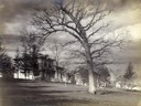
| Description: | John S. Fuller made this photograph of the three University buildings on Bascom Hill (then known as College Hill) from the Capitol roof about 1860. Grace E... |

| Date: | |
|---|---|
| Description: | Elevated view of residences and university buildings made from the Soldiers' Orphan's Home (aka the "Farwell house"). Three University of Wisconsin-Madison... |

| Date: | |
|---|---|
| Description: | Residences on Big Bug Hill (Pinckney and Gilman streets). The image was taken from the corner of Webster or Butler Street and Mifflin Street. |
If you didn't find the material you searched for, our Library Reference Staff can help.
Call our reference desk at 608-264-6535 or email us at: