 Filter: Categories of Wisconsin Historical Images
Filter: Subject of International relations
Filter: Subject of men
Filter: Categories of Wisconsin Historical Images
Filter: Subject of International relations
Filter: Subject of men
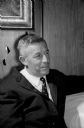
| Date: | 03 31 1959 |
|---|---|
| Description: | Portrait of Henry May, member of the New Zealand Parliament. May was a guest of the U.S. State Department and visited and spoke in several cities and in co... |
| Date: | 02 02 1951 |
|---|---|
| Description: | Front cover of the menu and program for the Fifth Anniversary of the Secretary-Generalship of Trygve Lie, first Secretary-General of the United Nations (UN... |
| Date: | 11 27 1950 |
|---|---|
| Description: | Front cover of the menu for a dinner given by Nazrollah Entezam, President of the United Nations (UN) General Assembly during its fifth session and leader ... |
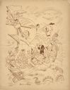
| Date: | 06 05 1943 |
|---|---|
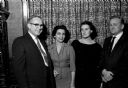
| Description: | From left to right: Sir William Beveridge, author of the British "Cradle to the Grave" social security plan, and Arthur J. Altmeyer, Chairman of the Social... |

| Date: | 02 17 1960 |
|---|---|
| Description: | People from all over the world, many wearing native dress, attend the Rotary International Dinner. Left to right are: Leo Barker, Wisconsin Rapids; Rohini ... |
| Date: | 02 17 1960 |
|---|---|
| Description: | The Rotary Club International Dinner honors international students in Madison. Many other guests from foreign countries were also invited. From left are: D... |
| Date: | 1951 |
|---|---|
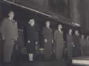
| Description: | View of group of people standing on stage at the Inter-American Conference on Social Security. Arthur J. Altmeyer stands in the middle. Eva Peron stands se... |
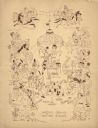
| Date: | 02 26 1942 |
|---|---|
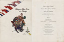
| Description: | Front cover and menu page from the program for the Third Annual Dinner of the Overseas Press Club of America for Anti-Axis Solidarity, with an illustration... |
| Date: | 02 11 1961 |
|---|---|
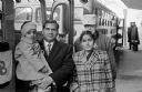
| Description: | Ninety-two foreign students attending the U.W., Beloit, and Milton Colleges representing 35 countries took buses to Janesville where they were guests of th... |

| Date: | 07 28 1960 |
|---|---|
| Description: | Promoters of understanding between neighboring countries and of labor problems within countries are shown conversing. Charles Maquire (center), is team man... |

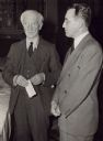
| Date: | 11 15 1989 |
|---|---|
| Description: | Congressman David Obey and Chairman of Solidarity Lech Walesa of Poland shake hands. |
| Date: | |
|---|---|
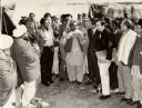
| Description: | Congressman David Obey outdoors in a group of men listening to a speaker in the Middle East. They are surrounded by tents. |
| Date: | 04 24 1939 |
|---|---|
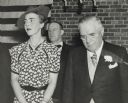
| Description: | Princess Ingrid of Denmark with Wisconsin Governor Julius Heil. The princess is wearing a floral patterned short sleeved dress, a pearl necklace, earrings,... |

| Date: | 10 30 1965 |
|---|---|
| Description: | Critics and supporters of the United States policy in Viet Nam discuss their views at a meeting of the policy committee of the University of Wisconsin Youn... |

| Date: | 10 30 1965 |
|---|---|
| Description: | Critics and supporters of the United States policy in Viet Nam discuss their views at a meeting of the policy committee of the University of Wisconsin Youn... |

| Date: | 1715 |
|---|---|
| Description: | One of Herman Moll's most famous maps, often referred to as The Codfish Map, it shows rivers and portages, cities, Indian villages, wind directions, routes... |

| Date: | 1758 |
|---|---|
| Description: | This map of the north-west hemisphere shows the cities, lakes, rivers, mountains, and political borders. In the upper left corner sits a decorative cartouc... |

| Date: | 1755 |
|---|---|
| Description: | This map shows the eastern half of North America during the French and Indian war, including cities, borders, Native American Land, forts, and detailed geo... |

| Date: | 1783 |
|---|---|
| Description: | This map is hand-colored and shows the boundaries of British, Spanish, and the newly recognized American claims, as well as the fishing rights granted to F... |
| Date: | |
|---|---|
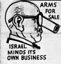
| Description: | Profile portrait of bald-headed man wearing a pair of eyeglasses with a cannon in place of his nose. At the top the text reads: "Arms For Sale," and at the... |
If you didn't find the material you searched for, our Library Reference Staff can help.
Call our reference desk at 608-264-6535 or email us at: