 Filter: Categories of Wisconsin Historical Images
Filter: Subject of International relations
Filter: Subject of botany
Filter: Categories of Wisconsin Historical Images
Filter: Subject of International relations
Filter: Subject of botany

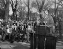
| Date: | 11 04 1949 |
|---|---|
| Description: | Elevated view of a large crowd of people gathered on the University of Wisconsin Union Terrace to listen to a speech by Prime Minister Pandit Jawaharlal Ne... |

| Date: | 02 25 1971 |
|---|---|
| Description: | Poster advertising the Model United Nations at the University of Wisconsin-Madison. Features a dove with an olive branch as a symbol of peace. |

| Date: | 03 21 1950 |
|---|---|
| Description: | Five women chatting informally before the annual Matrix Banquet at Memorial Union. They are, left to right: Mrs. Lyman Dunn, Chicago, national president of... |
| Date: | 10 24 1950 |
|---|---|
| Description: | Corporal Albert Griffin, a soldier from Milwaukee wounded in the Korean War, addressing the crowd gathered at the Wisconsin State Capitol on United Nations... |

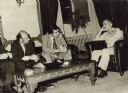
| Date: | 1943 |
|---|---|
| Description: | President Franklin Roosevelt and Mrs. Roosevelt on the officials platform during a visit to Monterrey, Mexico. Standing between them (and also pictured on ... |

| Date: | 09 1944 |
|---|---|
| Description: | Prime Minister Winston Churchill greets President Franklin Roosevelt as he is about to exit his vehicle for their meeting at Quebec. This was their second ... |
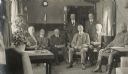
| Date: | 06 1917 |
|---|---|
| Description: | Group of Root Commission members sitting in "the drawing room car of the Imperial train of Ex-Czar Nicholas." Cyrus McCormick, Jr. is standing at right. Th... |
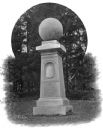
| Date: | |
|---|---|
| Description: | Also known as the monument to "The Birthplace of American Foreign Missions," the Haystack Monument was erected in 1867 by William College's Society of Alum... |
| Date: | 1975 |
|---|---|
| Description: | Congressmen David R. Obey of Wisconsin and Ed Koch of New York meeting with King Hussein of Jordan during a congressional tour of the Middle East. |
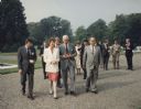
| Date: | 1991 |
|---|---|
| Description: | Mary Robinson, President of Ireland, escorting Speaker of the House of Representative Thomas Foley, who was heading a house leadership trip to Ireland. To ... |

| Date: | 1746 |
|---|---|
| Description: | A map of the western hemisphere, including parts of western Europe and Africa, showing the division of the Americas by the European powers. Weapons and fol... |

| Date: | 1715 |
|---|---|
| Description: | One of Herman Moll's most famous maps, often referred to as The Codfish Map, it shows rivers and portages, cities, Indian villages, wind directions, routes... |

| Date: | 1758 |
|---|---|
| Description: | This map of the north-west hemisphere shows the cities, lakes, rivers, mountains, and political borders. In the upper left corner sits a decorative cartouc... |

| Date: | 1755 |
|---|---|
| Description: | This map shows the eastern half of North America during the French and Indian war, including cities, borders, Native American Land, forts, and detailed geo... |

| Date: | 1783 |
|---|---|
| Description: | This map is hand-colored and shows the boundaries of British, Spanish, and the newly recognized American claims, as well as the fishing rights granted to F... |

| Date: | 1747 |
|---|---|
| Description: | Map of America showing rivers, lakes, mountains, and regions, but primarily focusing on the French and Native American settlements along the Mississippi th... |

| Date: | 1758 |
|---|---|
| Description: | Map showing lakes, rivers, cities, Native American land, and the boundaries of French and English claims in America and Canada north of New York. A title c... |

| Date: | 1755 |
|---|---|
| Description: | Map of North America east of the Mississippi River showing cities, settlements, Native American land, mountains, lakes, rivers, and the boundaries between ... |

| Date: | 1763 |
|---|---|
| Description: | Map of America and part of Canada including the borders of European claims after the French and Indian War. Cities, forts, Native American lands, rivers, l... |

| Date: | 1778 |
|---|---|
| Description: | Map of European claims in North America, with France shown as having claim to the most land, and the British colonies confined to east of the Appalacian Mo... |
If you didn't find the material you searched for, our Library Reference Staff can help.
Call our reference desk at 608-264-6535 or email us at: