 Filter: Categories of Wisconsin Historical Images
Filter: Subject of Great Lakes
Filter: Subject of human settlements
Filter: Subject of land
Filter: Categories of Wisconsin Historical Images
Filter: Subject of Great Lakes
Filter: Subject of human settlements
Filter: Subject of land

| Date: | 1799 |
|---|---|
| Description: | Map of North America from the Great Lakes region to Baffins Bay. It shows settlements, Native American land, cities, trading houses and forts, mountains, a... |

| Date: | 1755 |
|---|---|
| Description: | Map of colonial America, showing the lands north of South Carolina and west of the Mississippi River. An inset map of the Carolinas and Georgia sits in the... |

| Date: | 1720 |
|---|---|
| Description: | Detailed, ornate, and comprehensive map of America from the east coast to present day Texas. Numerous features appear throughout the map, including Native ... |

| Date: | 1755 |
|---|---|
| Description: | Map of the Great Lakes region during the French and Indian War. It shows in great detail the territories, borders and boundary lines, Native American tribe... |

| Date: | |
|---|---|
| Description: | Aerial view of Ephraim and Eagle Bay. A two-lane highway runs along the coastline. Caption reads: "Ephraim, Wisconsin." |

| Date: | |
|---|---|
| Description: | In 1935, 202 families from the northern regions of Michigan, Wisconsin, and Minnesota were selected for this resettlement project, located near Palmer, Ala... |

| Date: | 03 23 1915 |
|---|---|
| Description: | Text on front reads: "Steamship William E. Corey, entering Duluth and Superior Harbor, Wis." A steamship entering the harbor under the Aerial Lift Bridge, ... |
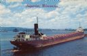
| Date: | 1936 |
|---|---|
| Description: | Text on front reads: "Superior, Wisconsin." On reverse: "Harry Wm. Hosford. This view was taken from the Arrowhead Bridge. It just unloaded its cargo of co... |
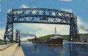
| Date: | 07 30 1952 |
|---|---|
| Description: | Text on reverse reads: "G-1–Ore Boat Leaving Duluth-Superior Harbor, Lift Bridge Raised. Giant lake freighters leave Duluth-Superior Harbor, the world's la... |
If you didn't find the material you searched for, our Library Reference Staff can help.
Call our reference desk at 608-264-6535 or email us at: