Filter: Categories of Wisconsin Historical Images
Filter: Subject of Fortification
Filter: Year of 1800-1899
Filter: Year of 1840-1849
Filter: Categories of Wisconsin Historical Images
Filter: Subject of Fortification
Filter: Year of 1800-1899
Filter: Year of 1840-1849
| Date: | 1849 |
|---|---|
| Description: | Fort Childs or New Fort Kearny in Nebraska Sketched by Wilkins on his 151-day journey from Missouri to California on the Overland Trail (also known as the ... |
| Date: | 05 1849 |
|---|---|
| Description: | Old Fort Kearney (Nebraska City). Sketched by Wilkins on his 151-day journey from Missouri to California on the Overland Trail (also known as the Oregon Tr... |

| Date: | 1842 |
|---|---|
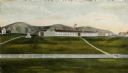
| Description: | This hand-colored lithograph of the second Fort Howard, with Indians canoeing on the Fox River, shows the hospital built 1834-1835 outside the stockade on ... |

| Date: | 06 24 1849 |
|---|---|
| Description: | Original wash drawing of Fort Laramie, Wyoming (actually Fort John; see note below). Sketched by Wilkins on his 151-day journey from Missouri to California... |
| Date: | 1840 |
|---|---|
| Description: | Photograph of a painting of the second Fort Crawford, built 1829-1835. Two men are in a boat in the water in the foreground. The first Fort Crawford at Pra... |

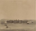
| Date: | 1848 |
|---|---|
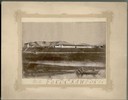
| Description: | The first Fort Crawford at Prairie du Chien, with the Mississippi River in the foreground. Although dated 1830, this scene was actually painted by Henry Le... |
| Date: | 05 1849 |
|---|---|
| Description: | Fort Leavenworth with trees, buildings and American flag. The fort was established by Colonel Henry Leavenworth to protect the Santa Fe trail against the I... |
| Date: | 07 25 1849 |
|---|---|
| Description: | Fort Bridger in Wyoming, with wagon parts and teepees, where Wilkins camped for a night; sketched by Wilkins on his 151-day journey from Missouri to Califo... |

| Date: | 1840 |
|---|---|
| Description: | This map, one of a series made by Thomas Jefferson Cram of the U.S. Topographical Engineers from personal surveys, shows the portage connecting the Wiskons... |

| Date: | 1840 |
|---|---|
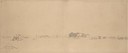
| Description: | Fort Crawford (the second site, with buildings of 1829-?), on the east bank of the Mississippi River, about 2 miles above the mouth of the Wisconsin River. |

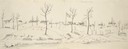
| Date: | 1840 |
|---|---|
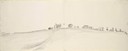
| Description: | A view of Fort Crawford (the second site and buildings of 1829-?). |

| Date: | 1846 |
|---|---|
| Description: | A hand-colored map of Wisconsin shows the counties in the state south and east of the Wisconsin and Fox rivers and the locations of Indian lands to the nor... |

| Date: | 1848 |
|---|---|
| Description: | A map of the Wisconsin and Iowa territories, with the surveyed counties of southern Wisconsin and eastern Iowa identified. The map shows the sectioning of ... |

| Date: | 1848 |
|---|---|
| Description: | Map of Wisconsin and a portion of Minnesota showing the township surveys in progress in portions of the Saint Croix River region and in central Wisconsin a... |

| Date: | 1847 |
|---|---|
| Description: | A hand-colored map that shows the area south and east of the Wisconsin and Fox Rivers, as well as a few landmarks just north of that area. The township gri... |

| Date: | 1840 |
|---|---|
| Description: | This map shows a line of proposed construction for defending the north side of the canal against inundation from the Wisconsin River and location of Fort W... |

| Date: | 1846 |
|---|---|
| Description: | This map shows the plotting of the various townships in Wisconsin, both those that had been surveyed and some outlines for those which have not. A note in ... |
If you didn't find the material you searched for, our Library Reference Staff can help.
Call our reference desk at 608-264-6535 or email us at: