 Filter: Categories of Wisconsin Historical Images
Filter: Subject of Forests and forestry
Filter: Subject of water
Filter: Subject of animals
Filter: Categories of Wisconsin Historical Images
Filter: Subject of Forests and forestry
Filter: Subject of water
Filter: Subject of animals
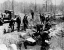
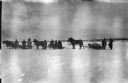
| Date: | 04 26 1936 |
|---|---|
| Description: | Planting trout in Waupaca County. Left to right on bank: S.A. LaVoilette, Joe Samz, Lloyd Pinkawski, Edwin Kargewski, W.M. Geiger, G. Moder, Billy LaVoilet... |
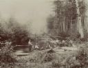
| Date: | |
|---|---|
| Description: | View from shoreline towards eight men trout fishing on the Brule River. |
| Date: | |
|---|---|
| Description: | Please listen to the great owl Please listen to the education Please learn how to save hard things for the easy way |
| Date: | |
|---|---|
| Description: | The log who was made King of Logs is here entombed eight round, ten long For his design, the strengthened forest capriciously outgrew them all... |
| Date: | 1918 |
|---|---|
| Description: | View across snow towards a group of soldiers from the mapping section of the 310th United States Engineer Corps posing with horses and sleighs. In the back... |

| Date: | 1930 |
|---|---|
| Description: | Original map made with watercolor and inkwash. Includes a legend of buildings, roads, natural features and other details of the lodge. Inset at bottom has ... |

| Date: | 1947 |
|---|---|
| Description: | This map shows various types of forests, nurseries, state fish hatcheries, major wood-using industries, camp & picnic grounds, fire towers, ranger stations... |

| Date: | |
|---|---|
| Description: | Cigar box cover with a head and shoulders portrait of Nelson Dewey. Beneath his portrait is a Native American headdress, a tomahawk, a stone club and a qui... |

| Date: | 1733 |
|---|---|
| Description: | This map of North America shows settlements, rivers, lakes, Native American land, trade winds, and numerous topographical features such as forests and moun... |

| Date: | 1740 |
|---|---|
| Description: | Map including the regions and cities of the northern half of North America. Native American land, rivers, lakes, mountains are labeled. Mountains, marshes,... |

| Date: | 1720 |
|---|---|
| Description: | Detailed, ornate, and comprehensive map of America from the east coast to present day Texas. Numerous features appear throughout the map, including Native ... |

| Date: | 1719 |
|---|---|
| Description: | Map of Maryland and surrounding states. It shows the boundaries, counties, cities, towns, rivers, and bays. Mountains, forests, and swamps appear pictoria... |

| Date: | 1671 |
|---|---|
| Description: | Map of Virginia depicting the discoveries detailed by John Smith in his exploration of the region. It shows Jamestown, Native American tribes and villages,... |
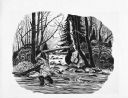
| Date: | 1962 |
|---|---|
| Description: | Imaginative pen-and-ink drawing of a fisherman wearing waders in a creek at the juncture of a cascading stream. He is surrounded by trees and forest berms.... |

| Date: | 11 1963 |
|---|---|
| Description: | In the woods, a man is cooking over a campfire, while a deer carcass is hanging from the branch of a tree. Sid's poem accompanying the image in the newspap... |
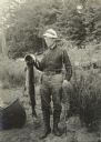
| Date: | 1916 |
|---|---|
| Description: | Former Senator Brazeau of Grand Rapids, Wisconsin posing near a canoe. He is holding his fishing pole and a large muskie. |

| Date: | 1911 |
|---|---|
| Description: | Indian women paddle their canoes on Rainy Lake. Other people and dogs are on the shore. |

| Date: | 1910 |
|---|---|
| Description: | View across water towards a bark canoe resting at an Indian camp on the shore of Lac La Croix. There are several dogs at the camp. |
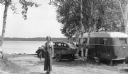
| Date: | 07 1939 |
|---|---|
| Description: | A young woman is standing and posing with a stringer of panfish in front of a car with a small travel trailer behind it. She is wearing a wide leg bib over... |
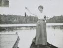
| Date: | 1899 |
|---|---|
| Description: | Annie McClure is standing in a boat showing the fish she caught on Archibald Lake. There is a pier on the left, and a tree-lined shore is in the background... |
If you didn't find the material you searched for, our Library Reference Staff can help.
Call our reference desk at 608-264-6535 or email us at: