 Filter: Categories of Wisconsin Historical Images
Filter: Subject of Forests and forestry
Filter: Subject of persons
Filter: Type of Map or Atlas
Filter: Categories of Wisconsin Historical Images
Filter: Subject of Forests and forestry
Filter: Subject of persons
Filter: Type of Map or Atlas

| Date: | 1958 |
|---|---|
| Description: | Includes images of Flambeau River State Forest and a description of, canoeing and recreational activities in, and general park and forest information about... |

| Date: | 1960 |
|---|---|
| Description: | This mid-20th century tourist brochure for Bayfield County, Wisconsin, includes a map of the county showing towns, cities and villages, highways and roads,... |

| Date: | 1967 |
|---|---|
| Description: | This tourist brochure for Bayfield County, Wisconsin, from 1967 includes a map of the county showing towns, cities and villages, highways and roads, railro... |

| Date: | 1930 |
|---|---|
| Description: | Original map made with watercolor and inkwash. Includes a legend of buildings, roads, natural features and other details of the lodge. Inset at bottom has ... |

| Date: | 1755 |
|---|---|
| Description: | This map shows the eastern half of North America during the French and Indian war, including cities, borders, Native American Land, forts, and detailed geo... |

| Date: | 1630 |
|---|---|
| Description: | One of the few maps by Dutch cartographer Willem Blaeu depicting the Americas, this map shows regions, settlements, islands, mountains, forests, rivers, an... |

| Date: | 1733 |
|---|---|
| Description: | This map of North America shows settlements, rivers, lakes, Native American land, trade winds, and numerous topographical features such as forests and moun... |

| Date: | 1740 |
|---|---|
| Description: | Map including the regions and cities of the northern half of North America. Native American land, rivers, lakes, mountains are labeled. Mountains, marshes,... |

| Date: | 1720 |
|---|---|
| Description: | Detailed, ornate, and comprehensive map of America from the east coast to present day Texas. Numerous features appear throughout the map, including Native ... |

| Date: | 1667 |
|---|---|
| Description: | Map of Virginia depicting the discoveries detailed by John Smith in his exploration of the region. It shows Jamestown, Native American tribes and villages,... |

| Date: | 1671 |
|---|---|
| Description: | Map of Virginia depicting the discoveries detailed by John Smith in his exploration of the region. It shows Jamestown, Native American tribes and villages,... |

| Date: | 1761 |
|---|---|
| Description: | Map covering southern Louisiana from Lake Ponchetrain to the Golf of Mexico and from Woods Bay in the west to the islands just east of Bay St. Louis. It sh... |
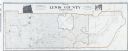
| Date: | 1909 |
|---|---|
| Description: | A map of Lewis County, Washington. There are two photographs at the top, an exterior and interior view of the bank building of Coffman, Dobson, & Co. Banke... |
If you didn't find the material you searched for, our Library Reference Staff can help.
Call our reference desk at 608-264-6535 or email us at: