Filter: Categories of Wisconsin Historical Images
Filter: Subject of Forests and forestry
Filter: Type of Map or Atlas
Filter: Categories of Wisconsin Historical Images
Filter: Subject of Forests and forestry
Filter: Type of Map or Atlas

| Date: | 1795 |
|---|---|
| Description: | Map of New Jersey showing counties, cities, towns, mills, landowners, roads, mountains, bays, rivers, and lakes. A few annotations dot the map, describing... |

| Date: | 1673 |
|---|---|
| Description: | Decorative map of the southeastern region of North America, from the York River in Virginia to northern Florida. The coat of arms of France and England mar... |

| Date: | 1667 |
|---|---|
| Description: | Map of Virginia depicting the discoveries detailed by John Smith in his exploration of the region. It shows Jamestown, Native American tribes and villages,... |

| Date: | 1671 |
|---|---|
| Description: | Map of Virginia depicting the discoveries detailed by John Smith in his exploration of the region. It shows Jamestown, Native American tribes and villages,... |

| Date: | 1676 |
|---|---|
| Description: | Map of Virginia and Maryland, based on John Smith's 1612 map and Augustine Herman's 1673 seminal map. It shows borders, counties, Native American land, tri... |

| Date: | 1761 |
|---|---|
| Description: | Map covering southern Louisiana from Lake Ponchetrain to the Golf of Mexico and from Woods Bay in the west to the islands just east of Bay St. Louis. It sh... |

| Date: | 1759 |
|---|---|
| Description: | Map of New Orleans at the start of the French & Indian War, including two inset maps entitled "The Course of the Mississipi River from Bayagoulas to the Se... |

| Date: | 1769 |
|---|---|
| Description: | Map of New Orleans at the start of the French & Indian War, including two inset maps of the Mississippi River Delta and Fort la Balise. It shows streets, r... |

| Date: | 1761 |
|---|---|
| Description: | Map of New Orleans with north oriented towards the upper right corner. It shows the land around the city, the Mississippi River, anchorages, roads leading ... |

| Date: | 1793 |
|---|---|
| Description: | Detailed topographical map of the Ohio River between Clarkville and Louisville. It shows plots of farmland, forest, islands, garden plots, houses, Fort Fe... |

| Date: | 1933 |
|---|---|
| Description: | This map contains automobile routes across Wisconsin and portions of Illinois, Iowa, Minnesota and Michigan as well. The state borders are clearly defined... |

| Date: | 1962 |
|---|---|
| Description: | This colored map represents "Tour #1" of a series of driving tours of the state published by the Sperry & Hutchinson Company, in order to "help you enjoy W... |

| Date: | 1972 |
|---|---|
| Description: | A topographic map of the Blackwell quadrangle. |

| Date: | 1971 |
|---|---|
| Description: | A topographical map of the Grand View NW quadrangle. |
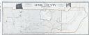
| Date: | 1909 |
|---|---|
| Description: | A map of Lewis County, Washington. There are two photographs at the top, an exterior and interior view of the bank building of Coffman, Dobson, & Co. Banke... |
| Date: | 1982 |
|---|---|
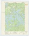
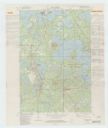
| Description: | A map of the Hazelhurst quadrangle annotated with railroad information. |
If you didn't find the material you searched for, our Library Reference Staff can help.
Call our reference desk at 608-264-6535 or email us at: